The Archaeology of the Limes Maritimus Scythicus (ArchLiMar), formerly Danube Delta Underwater Heritage.
We are pleased to announce that the accomplishments of the ArchLiMar Danube Underwater Heritage Project from the 2017-2019 seasons to date have been published:
Goals & ideas
The line of the Scythian stretch of the lower Danube (modern day Dobruja) was heavily fortified during the Roman period. Along the boundary marked by the big river rose a chain of fortresses: Durostorum, Sucidava, Axiopolis, Capidava, Cavsium, Arrubium, Noviodunum or Aegyssus, to name a few. The nautae universi Danuvi and the war fleet classis Flavia Moesica (at Noviodunum) were active here, as well as many civilian and military transport vessels.
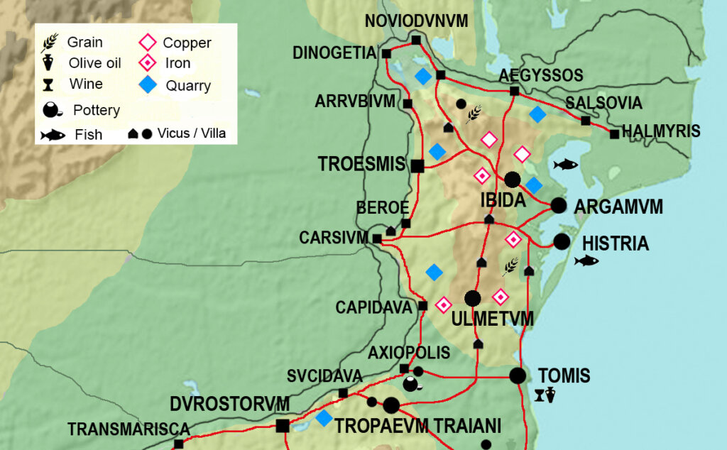
Ships that wished to navigate the Danube and reach inland centers directly on its banks typically had to enter the Sulina or Sfântu Gheorghe branches directly from the Black Sea basin. The navigable rivers, in addition to the road network, were very important communication and trade routes. They supplied goods not only necessary for the functioning of the legion camps, but also goods for trade.
The land route in turn crossed the Dobruja East to West, following river valleys through the hilly landscape. These roads were a welcome addition to the river route and – in winter – also a necessary “plan B”.
The ArchLiMar project aims to investigate both transport routes in the Roman and Late Roman period (1st through 6th century AD) and, by extension, their significance in earlier and later times based on any finds and observations from outside the preferred chronological framework. In our project we rely heavily on non-invasive methods of archaeological prospection, that is sonars and radars for underwater research and geophysical methods for land surveys. In addition, in places chosen based on results of the former, we also implement a direct approach with divers underwater and excavations on land.
The first three seasons of the non-invasive underwater project “The Danube Underwater Heritage: Trade and Shipwrecks at the Lower Danube and the Danube Delta” in Romania as part of the ArchLiMar framework are completed. Their implementation was possible thanks to the cooperation agreement between the University of Warsaw and the Gavril Simion Eco-Museum Research Institute in Tulcea (Romania). The project directors are Dr. Martin Lemke and Dr. George Nuţu, respectively.
The 2025 season
The 2025 campaign was the first one supported by the National Science Centre Poland (NCN) within the OPUS programme, under the project name “From Argamum to Troemis. Land and water routes in northern Dobruja in Antiquity” (project no. 2024/53/B/HS3/03471)
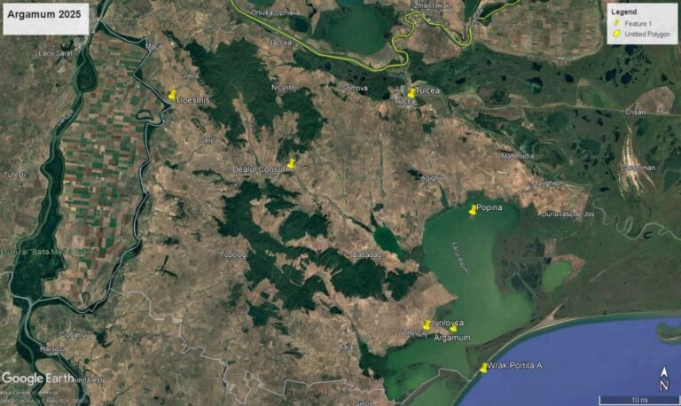
Fieldwork took place at Argamum, Dealul Consul, as well as Underwater in the Razim lagoon and the Black Sea. The main objective of the “From Argamum to Troemis. Land and water routes in northern Dobruja in Antiquity” project is to investigate the two principal communication routes connecting the Roman Danube frontier sites in Moesia inferior / Scythia minor with the Black Sea: on water through the Delta (taking into account its changes across two millennia) and then along the Danube, but also on land from Argamum on the Razim Lake following the Taiţa river towards the legionary fortress Troesmis. The idea is to clarify the relationship between the Danube river and the Black Sea for the Roman Empire from a military and logistic standpoint in general.
Accordingly, important research questions concern the role of the Taiţa valley supply route, both for military and civilian needs, the relationship between Argamum and the bigger town of Histria, both located on the same lake/lagoon (but the latter’s harbour silted up already in Antiquity) and also, with regard to the investigated fortifications of Argamum, Dealul Consul and others, the Late Antique settlement dynamics in Dobruja, in a violent but perhaps not as chaotic as believed period (particularly the 3rd and 4th centuries). These goals are met by land and underwater archaeological prospection as well as excavations on land in northern Dobruja. The following are excerpts from the general report prepared by Martin Lemke, Ada Gizińska, Michał Pisz, Karolina Trusz, Hanna Tręda, and Jan Niemyski.
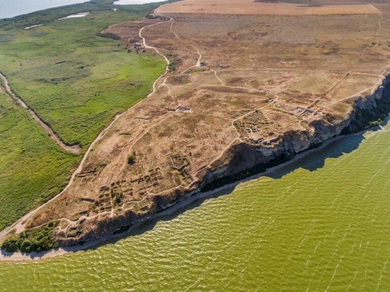
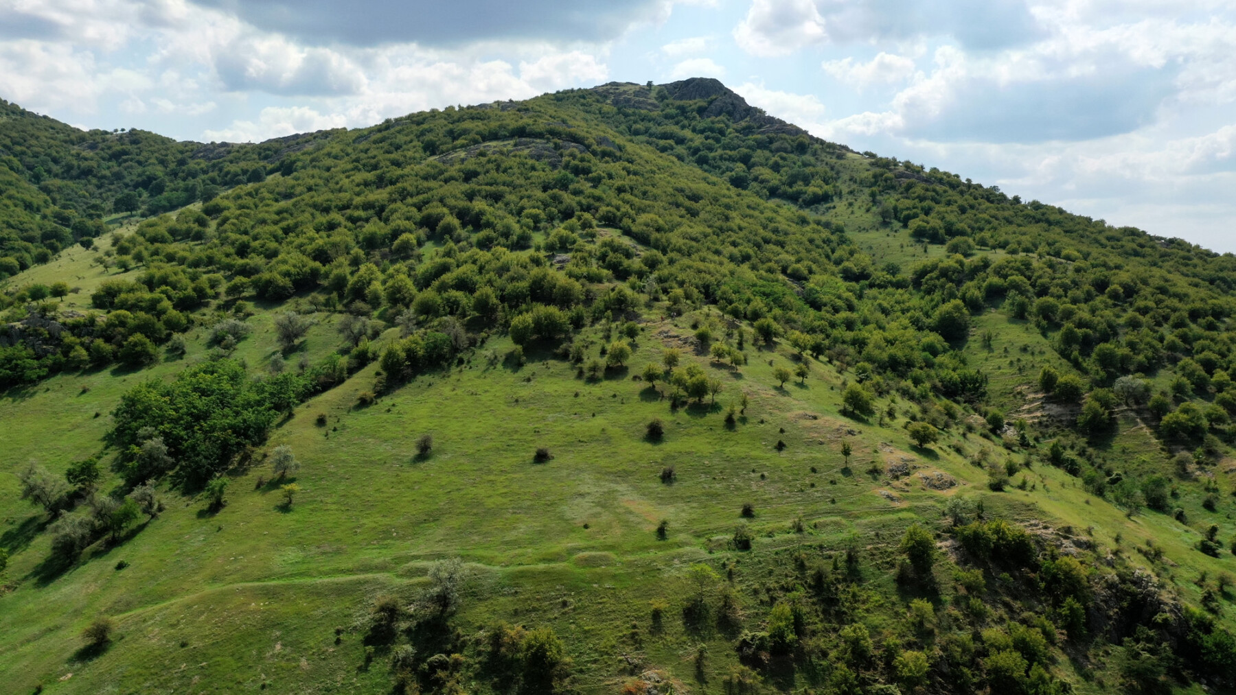
At Dealul Consul, the hitherto unknown late Roman hillfort or fortified town built on the slopes of the isolated hill in the Taiţa River valley, which crosses Dobruja on a northwest-southeast axis, and has been surveyed twice in the past, was investigated with geophysical prospection as well as a very small but crucial trial trench across the fortification wall. As a result, it was possible to determine the course of the defensive walls and select areas for future investigations. Additionally, a geophysical survey was undertaken at the site of Aegyssus in present day Tulcea, taking advantage of the opportunity to investigate another site crucial for Roman control and logistics in the northern Dobruja.
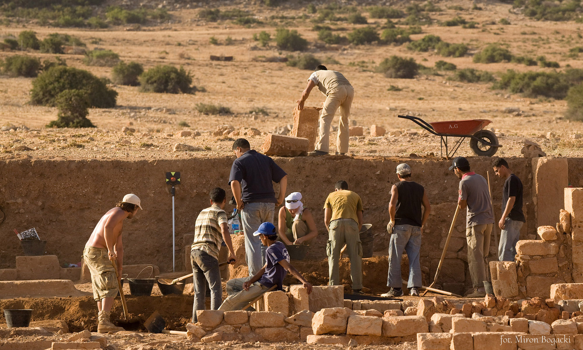
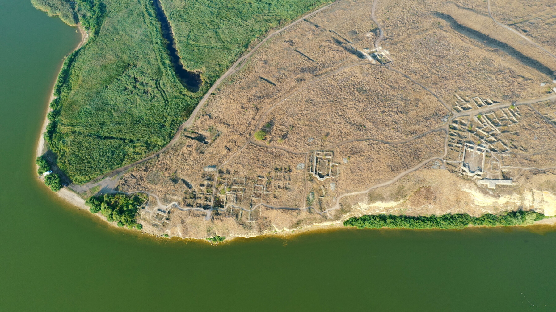
Argamum – Excavations
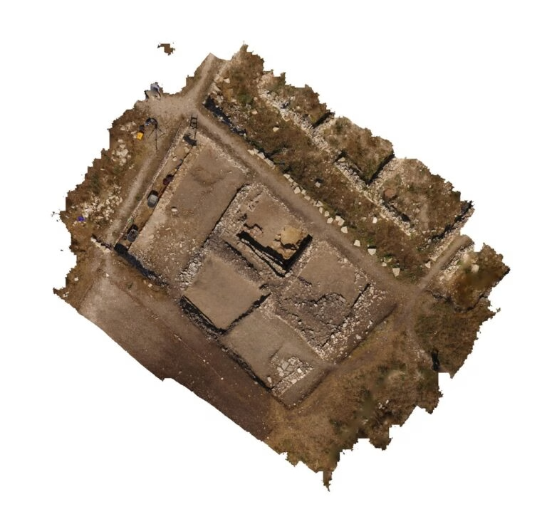
The focal point is the Greek, Roman and Late Roman city of Argamum, where in 2025 fieldwork was continued in the “Northern Sector”, an area connected to storage and logistics of the town in Justinian times, as well as on geophysical prospection in different parts of the city and extra muros.
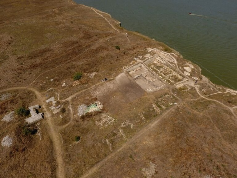
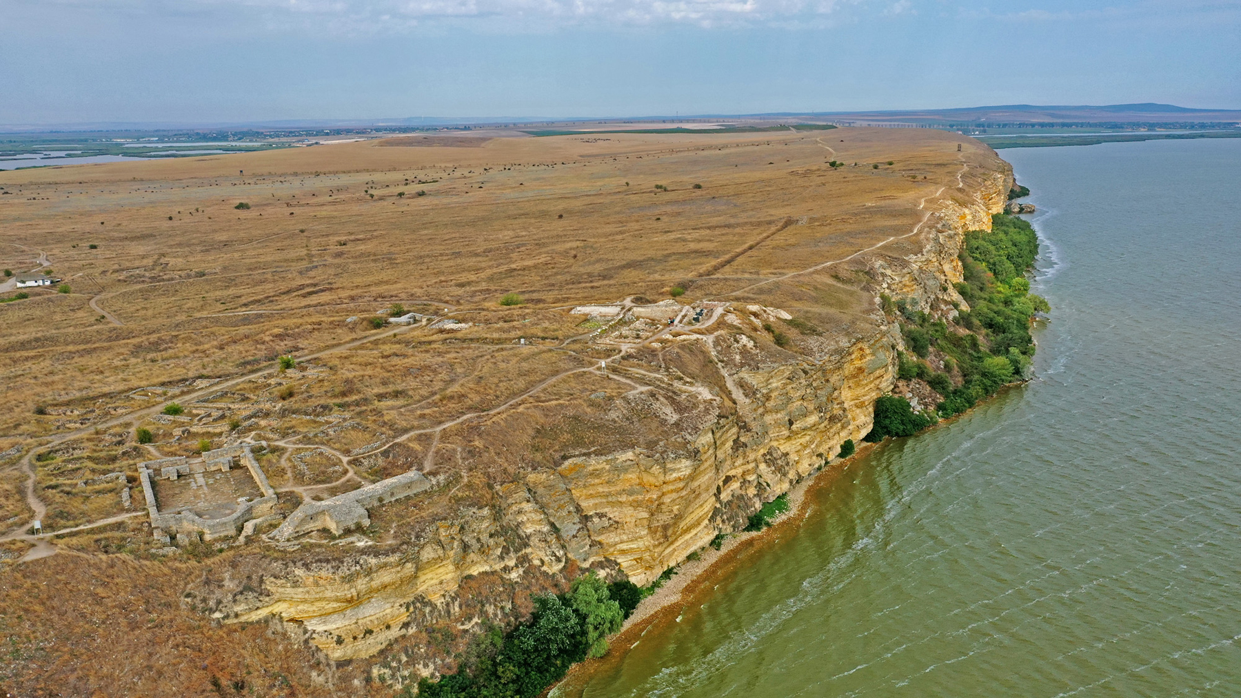
Argamum, Northern Sector 2025, view on the excavated area in its relation to the fortification wall and main gate
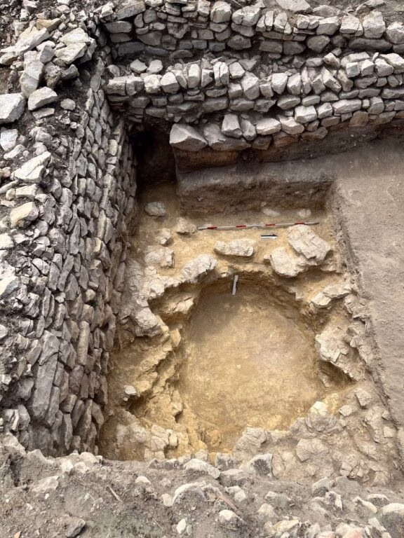
In general, both the architecture/features with the dolium pit and hearth as well as the small finds with fishing weights, lamps and particularly amphorae and dolia fragments discovered in the 2025 campaign emphasize the established interpretation of the northern sector being the storage quarter of the Justinian citadel, located in a secure but at the same time peripheral part of the area intra muros. Future campaigns will establish whether this logistic complex stretches all the way to the main/big gate of the citadel towards the West.
Argamum 2025 – Geophysics
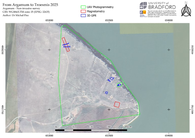
The archaeological prospection campaign undertaken at the sites of Argamum, Dealul Consul, and Aegyssus aimed to provide a non-invasive assessment of subsurface archaeological remains and landscape features associated with the ancient settlements. The surveys were designed to assist in the characterization of the sites’ extent, internal organization, and preservation conditions, and to inform the planning of future archaeological excavations and research strategies.
UAV Photogrammetry
The UAV photogrammetric survey covered the tip of Dolosman peninsula (ca. 35 ha). Two flights were taken that captured approximately 560 photographs per mission. Eighteen GNSS RTK-derived ground control points (GCPs) were established across the area to ensure sub-decimetric positional accuracy. The resulting orthomosaic achieved a resolution of approximately 3 cm per pixel, while the digital terrain model (DTM) achieved approximately 24 cm per pixel.
Non-invasive survey extent at Dealul Consul, with the survey extent with each of the applied methods outlined
A separate high-resolution photogrammetric case study was performed over Basilica II, involving 140 photographs and 22 GCPs, producing an orthomosaic with a resolution of 0.5 cm per pixel. This dataset was intended for use in data dissemination and public engagement, including 3D visualization and online presentation.
The orthophotomap and DTM provide the most detailed spatial model of Argamum to date, revealing a wide range of archaeological and geomorphological features, including embankments, structural remains, potential road alignments, gate structures, tumuli, and the traces of older excavation trenches. Several previously unrecorded linear trends of uncertain origin were also detected.
Magnetometry
Two areas were surveyed with the Bartington Grad601-2 magnetometer, selected to address specific research questions derived from earlier research campaigns.
- Northwest Area (120 × 20 m): targeted the presumed route of a Roman aqueduct.
- Southeast Area (40 × 40 m): aimed to locate potential kiln installations.
In the NW area, the survey successfully detected several anomalies, including a strong positive linear feature running roughly N–S, additional linear trends of varying polarity, and several small circular negative anomalies that may correspond to tumuli, commonly attested in this area.
In the SE area, four strong positive magnetic anomalies were recorded, three of which were of similar intensity, while the southeastern one was fainter. The anomalies exhibit thermoremanent magnetic signatures, suggesting the presence of kiln remains or other heat-affected features.
Preliminary interpretation: the magnetometry data confirm the presence of thermal structures in the SE zone (likely kilns) and possible aqueduct remains and burial mounds in the NW area.
“Basilica” Area: within Basilica II, two E–W linear reflections were identified just 10 cm below ground level (likely immediately beneath the pavement). Numerous point reflectors occur along them, and deeper (30 cm bgl) point reflectors align with these lines – possibly representing pillar bases or subsurface architectural elements.

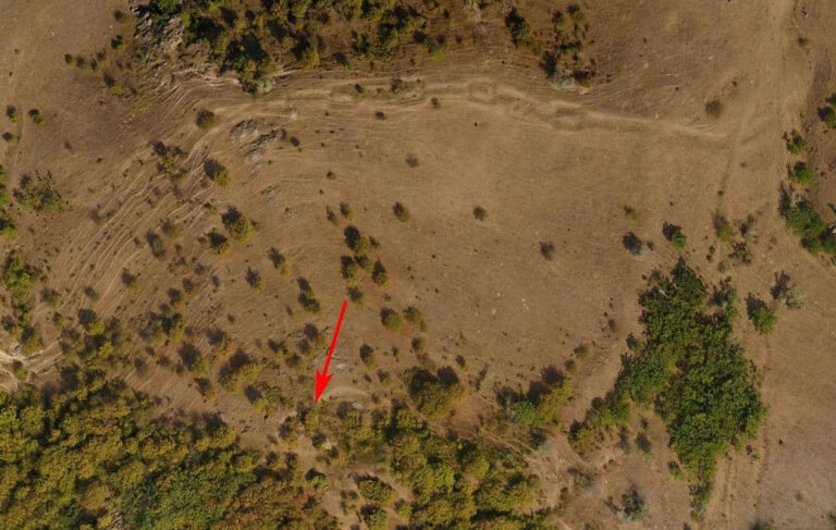
Dealul Consul 2025 – excavations
In order to verify the results of two non-invasive field surveys in 2023 and 2024, a small (2m x 2m) trail trench was set up at the south-western shoulder of the assumed fortification, within an expected tower (Tower 2, S1) in order to establish whether or not we deal with an actual wall. The excavation was located towards the upper end of the fortification, at a height of 105,00 m a.s.l. (as opposed to the entrance area at the bottom at a height of ca. 60 m a.s.l.)
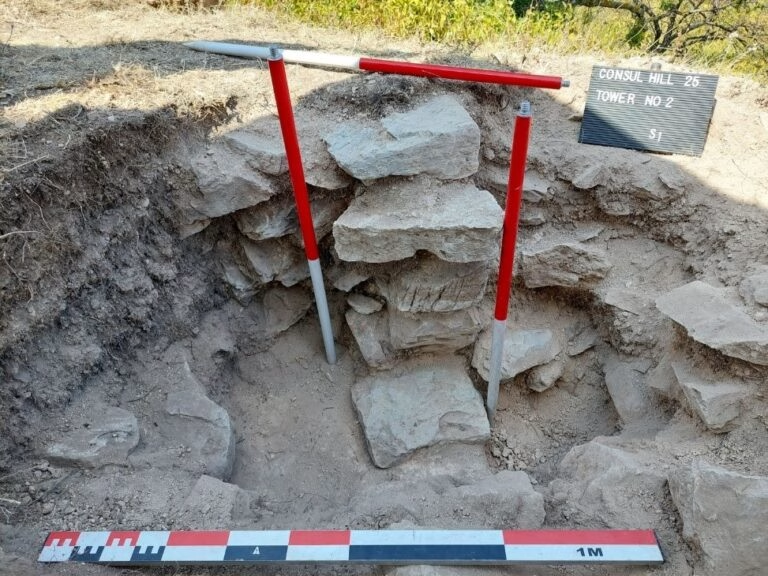
While the trench did not render any finds or ceramics other than bricks, it did reveal the coarsely worked stones of a fortification wall, bonded with mortar, thus unambiguously identifying the structure as a hillfort-like settlement, which based on the pottery discovered on the surface can be tentatively dated to the late 4th/5th century. After conclusion, the trial trench was refilled as per agreement with the National Reserve authorities.
Dealul Consul – geophysics
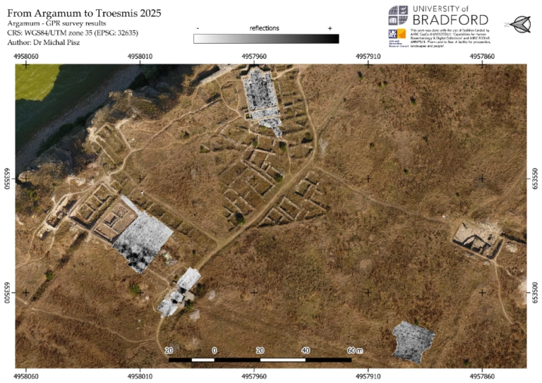
At Dealul Consul, a combination of UAV photogrammetry, ground-penetrating radar (GPR), magnetometry, and earth resistance (ER) surveys was undertaken in order to characterize the structural remains of the supposed fortress and its surrounding area. The site occupies a prominent position on a hilltop and includes an elevated stronghold and the slope descending toward the nearby river terrace.
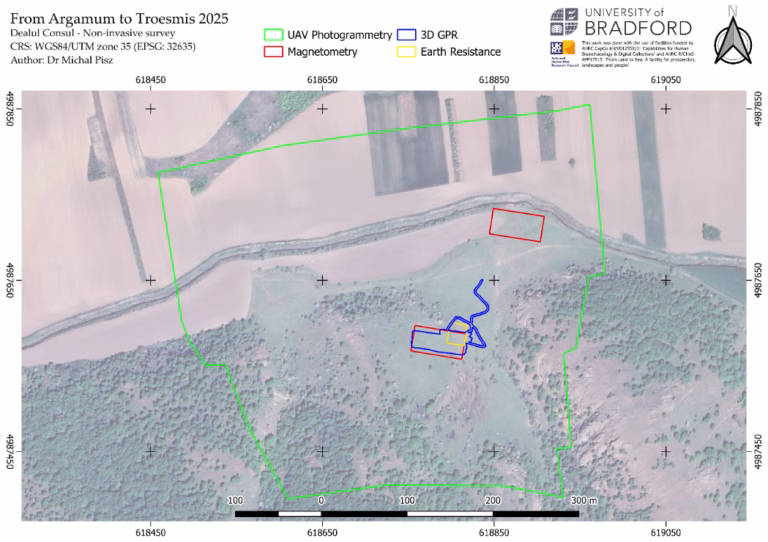
The geophysical survey targeted the northeastern corner of the presumed fortress, covering an area of approximately 0.18 ha with the GPR, two 30 × 60 m grids for magnetometry, and a 24 × 20 m area for earth resistance measurements. The UAV photogrammetric survey encompassed the entire site and its immediate surroundings (ca. 18 ha).
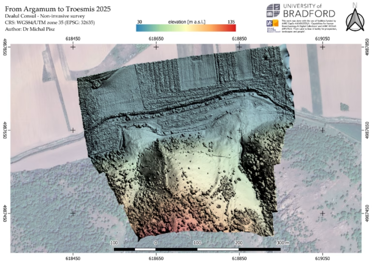
UAV Photogrammetry
The UAV survey produced a high-resolution orthomosaic (4 cm/pixel) and digital terrain model (DTM; 8 cm/pixel) processed in Agisoft Metashape using the RTK-derived ground control points. Both datasets revealed subtle topographic variations and surface traces consistent with buried architectural structures. These data provide a valuable spatial framework for the integration of the geophysical datasets and the planning of future excavation areas.
Preliminary interpretation: the photogrammetric results confirm the presence of presumed buried archaeological features. Buried masonry structures – possibly outer walls of the stronghold – are clearly visible in the DTM, supporting the discovery and contributing to the refinement of the site’s morphological understanding.
Ground-Penetrating Radar (GPR)
The GPR survey covered approximately 0.18 ha across the northeastern sector of the presumed fort and along two additional swaths extending down the outer slope. The results revealed a series of well-defined reflective anomalies within the stronghold, predominantly in its eastern part.
Preliminary interpretation: the GPR anomalies likely represent the remains of substantial architectural structures, possibly wall foundations or large masonry elements within the fortress complex. The circular/octagonal reflector may correspond to a tower base or architectural node, pending further verification.
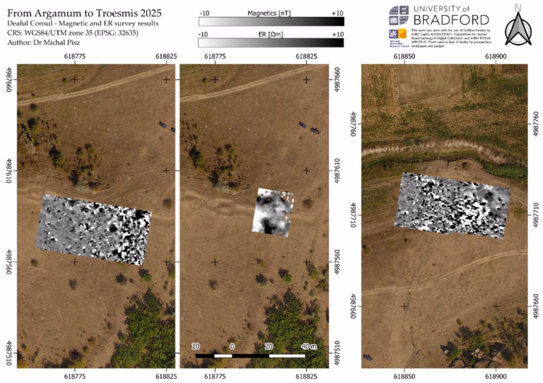
Magnetometry
Magnetic data were collected in two 30 × 60 m grids, one within the fortress and one at the foothill near the river terrace.
The lower (northern) area by the river exhibited a highly disturbed magnetic background with a dense distribution of dipolar anomalies, suggesting significant subsurface disturbance or anthropogenic activity, possibly related to past construction or industrial use. In contrast, the southern area within the fortress produced linear magnetic trends aligned N–S, corresponding to the GPR-detected structures, alongside several isolated dipolar responses in the western part of the grid.
Preliminary interpretation: the magnetometry results reinforce the GPR indications of buried wall alignments and structural elements within the fortress interior, while the foothill area appears to reflect zones of intense human activity, potentially associated with ancillary installations or later reuse of the site.
Underwater investigations
Underwater and water-related research activities in 2025 were divided into two main areas:
- studies on Lake Razim and its coastal zone – including work in the areas of Argamum and Popina Island;
- studies in the Black Sea and underwater/land prospection in the vicinity of the Periboina canal.
- Research on Lake Razim
- Argamum – the port hypothesis
During the 2025 season, preliminary geophysical investigations were carried out in the area adjacent to the Argamum site, surrounding the terrain of the presumed ancient harbour basin. The aim was to verify earlier assumptions regarding the location of the ancient harbour entrance and to identify potential directions for further research.
Existing results from German colleagues were reviewed, suggesting that the harbour entrance was located centrally on the eastern shore of Lake Razim; reference was also made to aerial photographs from 1931 (rather unclear, with no better-quality copies available).
The area was re-examined as far as possible by walking along the stony, grass-covered shoreline and by circumnavigating the area from the water. It was considered that the area where the stony beach now lies might once have been an extension of the mainland, forming a natural breakwater separating the sea from the harbour basin. The cape would have extended markedly southwards, ending to the southwest and creating a natural entrance to the presumed port basin. This is a working hypothesis which should be verified using a land-based drone with a magnetometer, as the dense vegetation prevents direct underwater exploration.
Recommendations for future research seasons:
- densify sonar transects to 10 m intervals for precise mapping of potential anomalies from the lake side;
- employ a drone-mounted magnetometer to detect subsurface structures;
- conduct further analysis of historical maps and aerial photographs (especially pre-war) to reconstruct former shorelines.
- Popina Island – survey of surface and underwater structures
2.1. Waters surrounding the island and the beach
The aim of this year’s work was to repeat sonar scanning along the southern coast of the island in order to analyse seabed changes that occurred over the past year. The area was selected because of the concentration of pottery found on the island, in other parts no fragments were recorded. Unfortunately, the underwater survey had to be cancelled due to an exceptionally low water level. About 50 m from the island, the water barely reached mid-calf, and the RIB (rigid inflatable boat) had to be dragged to shore by hands.
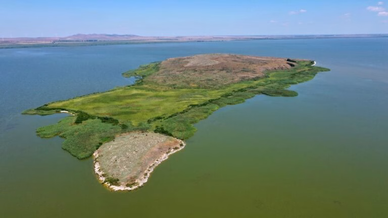
Numerous heavily abraded fragments of ancient pottery (including smooth, grooved and glazed sherds) were collected from the island’s beach. A natural profile of the island also formed, revealing a thick layer of fragmented shells. Basic photographic documentation was made.
2.2. On the island
Two anomalies previously recorded during 2024 drone flights were verified. These comprise four pillars within a rectangular trench and a square structure in the eastern, central part of the island. The square structure was built of rectangular stones and iron reinforcements – likely a transmitter tower, clearly of modern construction.
The trench with four pillars remains of uncertain function. The pillars are composed of neatly laid stones tapering upwards and partially excavated, protruding above ground level by about 3 m. The trench edges are steep, and although their purpose is unclear, the features most likely represent a modern installation.
The 2023 season
During the 2023 season, a considerable amount of time was devoted to fieldwalking on land to prepare the investigation of relevant sites in the Dobruja interior. The sites in question are a possible Roman temporary or marching camp, likely built out of wood and existing for a limited amount of time at Satu Nou and a Late Roman hilltop fort or fortified city built on the slopes of the isolated Dealul Consul (Consul Hill). Both sites are located in the valley of the Taiţa river, which crosses the Dobruja on a Northwest-Southeast axis. Upon inspection it was decided that both sites deserve investigations with non-invasive methods in the near future.
Regarding underwater research, the team revisited the waters of the Razim lagoon around Argamum, a Greek/Roman town, which is the focal point for our research. There the region across the lake up to Bisericuţa island, the area of the assumed harbour and a possible second port at the north end of the site were investigated with a side-scan sonar. The results will be published soon in the journal “Peuce”.
The 2019 season
In August and September 2019, the Black Sea coastal waters between the mouths of two branches of the Danube were prospected: Sulina and Sfântu Gheorghe. The area of activity was determined on the basis of finds of ancient pottery washed up on the beach in significant quantities south of the Sulina estuary.
The work schedule called for the two main activities to be carried out in parallel: fieldwalking on the beach and a sonar survey work from a boat. Due to the nature of the Danube Delta (a marshy area criss-crossed by canals), access to the area where the pottery was found was only possible from the boat on the seaward side. Therefore, the group conducting the surface prospecting would leave the boat at a distance from the beach in order to also check the coastal waters, while the other group would sonar at a safe distance from the shore.
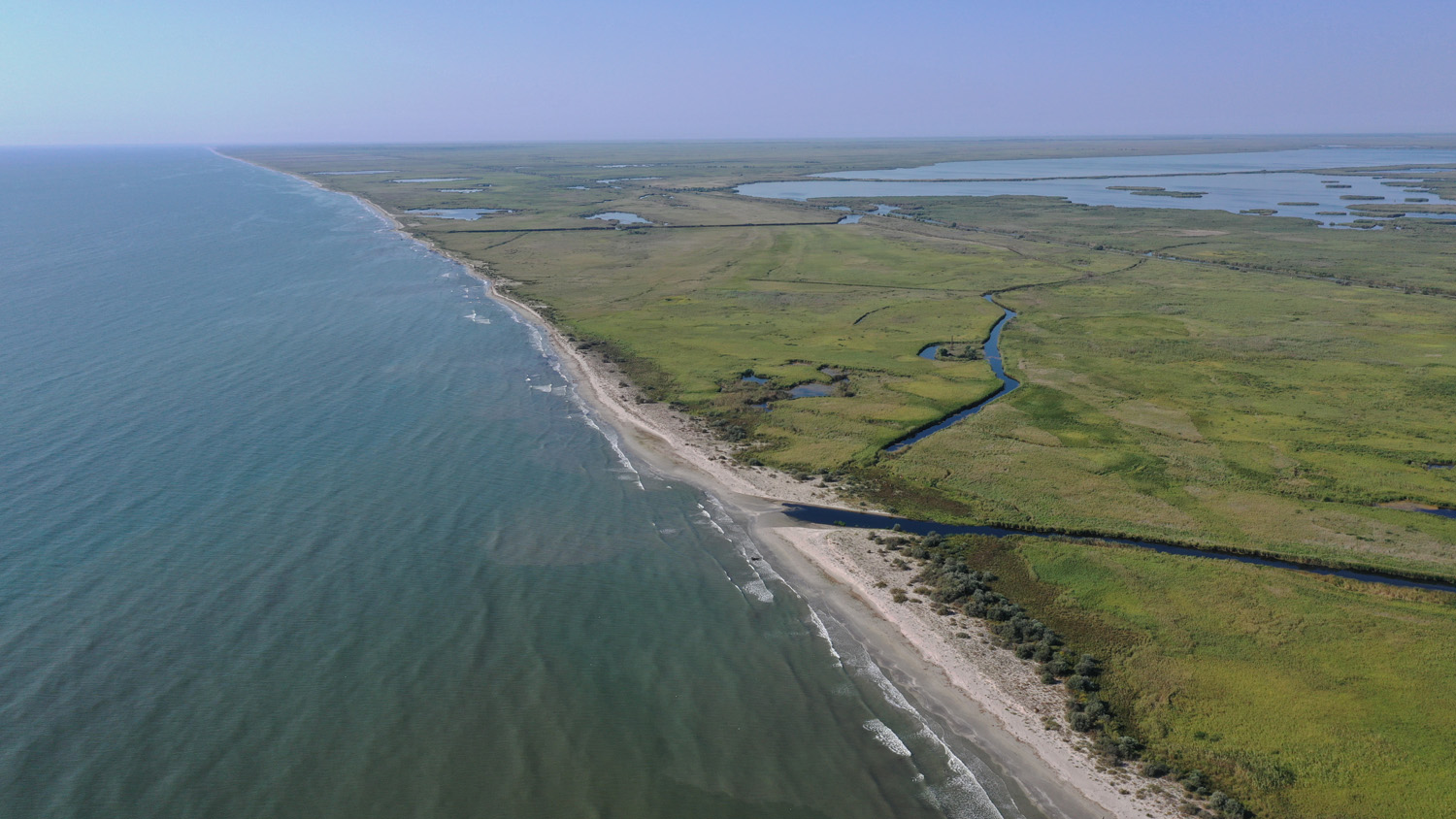
The survey area covered a six-kilometre stretch of beach starting north of the Gârla Impuţita channel to a point 2.5 km south of the Sondei channel. Here, ceramic fragments were found washed up on the beach and in the shallow waters of the foreshore.
During interviews with local people it was possible to establish that the increase in the occurrence of pottery finds on the beach follows storms and these are well-preserved, diagnostic pieces. The area prospected from the boat was characterised by a shallow depth (average 2 m) and a very irregular shaped bottom. A sandy bottom without any vegetation and high wave action favoured the formation of underwater shoals. These processes occur quite rapidly, resulting in a constantly changing seabed in the coastal zone.
Because the chosen body of water for the survey is so shallow, the bottom mapping took place in winds of less than 15 knots. The low waves did not cause interference when receiving signals from the seabed. The non-invasive underwater survey covered approximately 360 hectares. In this area, many shallows up to 0.5 metres were recorded, 500-600 metres from the shoreline the maximum depth was 4 metres.
Considerable amounts of ancient pottery and metal pieces, including anchor fragments, were located in the coastal zone. The artefacts were located on sandbanks with a bottom densely covered with grasses at a depth of approximately 0.5-0.7m. The sandbanks reached about 20 m from the waterline before sinking to a depth of about 1-2 m. There are strong currents at this location, which freely throw artefacts onto the shoals. The artefacts found were documented photographically and their coordinates were plotted on a map.
Points selected from the sonar image were checked during the dive. Currents at this low water level caused sea sediment to rise which made it difficult to make full observations underwater. The large thickness of organic bottom sediment precluded the discovery of clear wreck or sediment structures. A bathymetric plan of the verified part of the Black Sea was made.
Aerial verification, which was carried out using a drone, with a calm wave allows observation of the bottom formation. Clearly visible are the longitudinal mounds at the head of the Delta.
At this point, we are able to say more about the dynamic changes that the whole area is undergoing. Sediments deposited by rivers, on the one hand, cause the delta to continually grow, but sea currents, on the contrary, take away land in certain sections of the delta. The use of non-invasive methods was therefore crucial, as it enabled a large area of the seabed to be surveyed and bathymetric maps and GPS/GIS databases to be created.
The vascular ceramic material collected during the surface prospecting on the beach consisted mainly of fragments of amphorae. Most of the finds were quite heavily encased and irregularly encrusted with marine concretions. The compilation of this material is still in progress, but it is already apparent that the predominant amphorae are of the Shelov C type, which were produced on the southern Black Sea coast in the 2nd century AD and which were sent with supplies for the legionaries to many limes camps along the Danube, including Novae in northern Bulgaria, which has been studied by Polish missions for years. At one point with an accumulation of finds, several small fragments of marble slabs (this is probably Greek cipollino marble from Euboea) were also discovered.
The results have been published in the journal Novensia.
The 2017 season
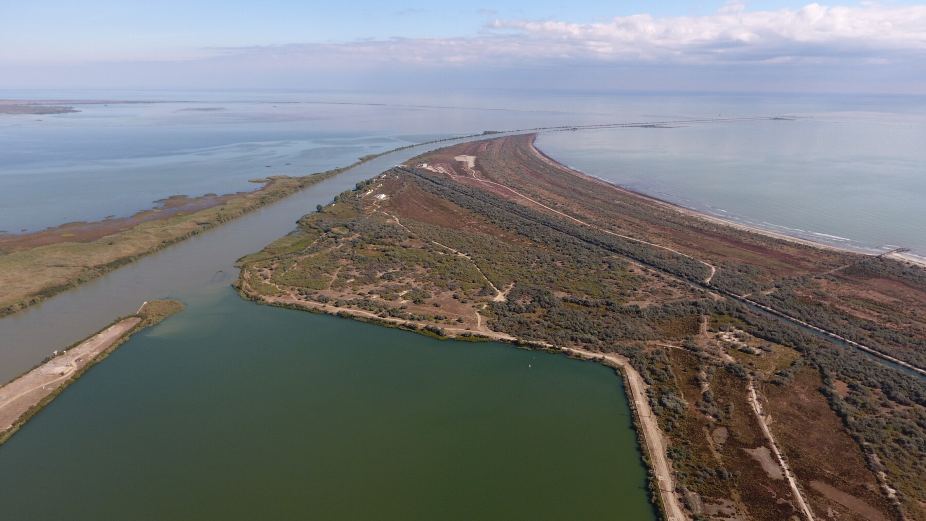
In 2017, the first research season of the ArchLiMar project took place, at that time under the working title “Danube Underwater Heritage”, during which various points within archaeological sites located in the Danube Delta were verified. The work was carried out from a boat using non-invasive methods: a side scanner and a bottom profiler were pulled behind the boat so that the acoustic streams covered the entire surveyed area. The images obtained in this way were then analyzed, and based on the data obtained, sites were selected for verification by divers. Dr. George Nuţu representing ICEM Tulcea and Marta Bajtler and Karolina Trusz from the University of Warsaw with a team of specialists set out on this task. The exploration covered Bazinul Mare (Sulina estuary) in the Danube Delta, but also Lake Sinoe adjacent to ancient Histria, and Lake Razim where ancient Argamum is located.
In the first case we had to deal with a semi-artificial reservoir, which was dug for large vessels entering the Sulina (one of the arms of the Danube), at the bottom of which numerous modern and early-modern boats and ships lay. Bazinul Mare is quite a shallow reservoir (maximum depth of 9-10 m), and due to the direct connection with the river there is very little visibility in it.
The area was checked with a sonar and bottom profiler, and selected points were verified by divers and documented where possible. A total of 21 anomalies were identified, of which 5 looked like potential wrecks. Due to very poor visibility in the water, 3 points were verified by divers. The effect of the underwater exploration of the above-mentioned points is the confirmation of the presence of three vessels on the day of the basin:
Shipwreck Sulina A – the best preserved of the discovered wrecks. Situated at a depth of 6 meters, visibility practically zero. The stern is invisible, buried in sediments. The preserved length ranges around 30m, it is a wooden hull with metal reinforcements. The wreck contained a set of cannonballs and probably a cannon. Numerous of these projectiles (30 cm in diameter) and a wooden wheel from a cannon were found. Interestingly, a second wheel is in the local museum. The cannon(s) was not located. A chain was also discovered on the wreck, which was patented in 1810, giving us a terminus post quem.
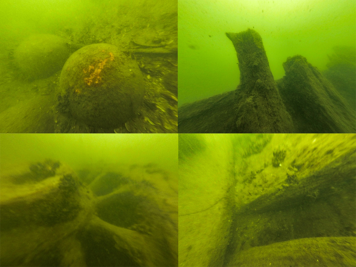
Shipwreck Sulina B – wooden wreck located at 8 m depth. Visibility is zero, so we could only confirm that there is a wooden vessel there.
Shipwreck Sulina C – wreck located at 6 – 7 m depth. Wooden structure, reinforced with metal plates. Wreck buried in the silt.
A major achievement of these investigations in Bazinul Mare was the inclusion of this area in the Romanian List of Monuments as an important heritage site, based on the mentioned shipwrecks, forbidding any sort of human intervention or construction works. The legislation was included as ORDIN nr. 2.102 from 15 February 2019: “ORDER no. 2.102 of February 15, 2019 of the Minister of Culture and National Identity regarding the classification as a historical monument of the building UAT Sulina, F12 intravilan, Hs63/4, nc810 in CF30510 UAT Sulina, Bazinul Mare Portuar, Bazinul Maritim, in the premises of AZL, Sulina city, Tulcea county, in the List of historical monuments, with the name Hydrotechnical and port facilities of the European Commission of the Danube CED from Sulina – Great Port Basin/Maritime Basin, Sulina city, Tulcea county, in category s – site, I – archaeology, in value group A”. Register of legislation: https://legislatie.just.ro/Public/DetaliiDocument/220429.
Prospecting on the lakes was even more difficult. Both are part of the same, very shallow Razim lagoon with zero visibility. Still, since part of the archaeological site Histria is currently under water, we are aware of reports that at low water levels walls appeared. Local researchers believe that these may have been city walls from the early Roman period. A stone structure, which is under a layer of silt, has been traced with a mobile RTK measuring device, but further verification is needed. The part of the lake in close proximity to the ancient city was also checked with sonar and profiler to look for further anomalies. Preliminary measurements, however, did not reveal anything spectacular.
In Argamum, during an earthquake, a part of the site, which is located on a high cliff, collapsed into the lake. The area from the shores of Argamum towards the island of Bisericuţa was checked using sonar and a bottom profiler. Localized anomalies will be checked during the next survey seasons.
The results have been published in the Światowit” Supplement Series U.

The ArchLiMar has been funded by the National Science Centre Poland within the project: „The Danube Underwater Heritage. Non-invasive underwater research along the Black Sea coast in the Danube Delta area”, Miniatura 2, nr 2018/02/X/HS3/01745.
Moreover, the project Non-invasive Underwater Prospecting of the Sulina and Sfântu Gheorghe Rivers (Danube Delta) in Romania was carried out under funding from the UW Research Movement Advisory Board (syg.10/II/2017) and a Microgrant awarded under UW internal grants. The project was carried out by members of SKN “Wod.o.Lot” and in collaboration with Archcom.