Person conducting excavation: dr Sławomir Wadyl Country: Poland
Site name: Nowy Chorów, pow. Słupski, woj. pomorskie
Type of the site: barrow cemetery
Involved institutions: Faculty of Archaeology, University of Warsaw
Description of the research: The cemetery in Nowy Chorów is located on a small elevation, along the edge of the valley cut by watercourses. Excavations in the necropolis were initiated in 2022. They were preceded by geophysical research, which was carried out using magnetic and electrical resistance methods. In the first two seasons of research, three barrows were examined and protection works were carried out on one barrow, where there is a large robbery pit. The research allowed us to initially determine the chronology for the 11th-12th century.
In fact, most of the burial mounds at the site have a quadrangular shape. Objects of this type are called the Orzeszkowo type. The term comes from the cemetery in Orzeszków in the district of Łobez, examined in 1921-1924. In their classic form, they are found only in Pomerania. Barrows of the Orzeszkowo type are basically four-sided, usually square embankments “closed” with a stone surround. Inside the mound, there are various stone constructions in the form of burial chambers or stone pavements. They are usually the burial place of several people. They are characterized by bi-ritualism – apart from the prevailing inhumation, cremation was also used. The “equipment” of the dead is usually very modest. Although the Orzeszkowo-type graves belong to the more intriguing category of funerary objects, they have not been studied in recent decades. There are 16 mounds at the site. They form two clusters – the larger (Western) consisting of 10 and the smaller (Eastern) with six barrows.
Each of the examined burial mounds is a different funeral story. The goal is to explore a few more embankments. And due to the fact that the last studies of objects of this type took place in the years 1966–1968 – then excavations were carried out in Żydów in the Koszalin district – the research has great scientific and cognitive potential.
Stanowisko w zimowej scenerii. Fot. Sławomir Wadyl / Site in the winter scenery. Photo Sławomir Wadyl
Jeden z badanych kurhanów. Fot. Sławomir Wadyl / One of excavated mounds. Photo Sławomir Wadyl
Ułożony z kamieni symbol trykwetry odkryty w kurhanie. Fot. Sławomir Wadyl / A symbol of a triskelion made of stones discovered in a burial mound. Photo. Sławomir Wadyl
Kurhan w trakcie eksploracji. Fot. Sławomir Wadyl / A mound during exploration. Photo. Sławomir Wadyl
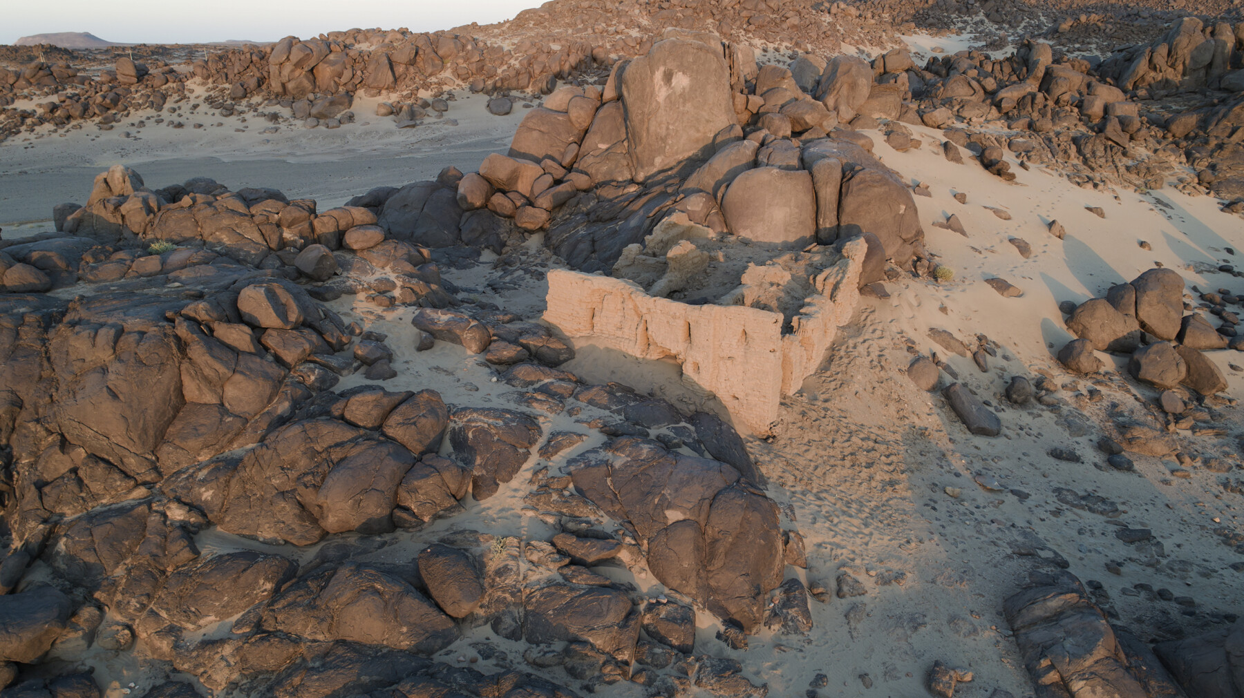
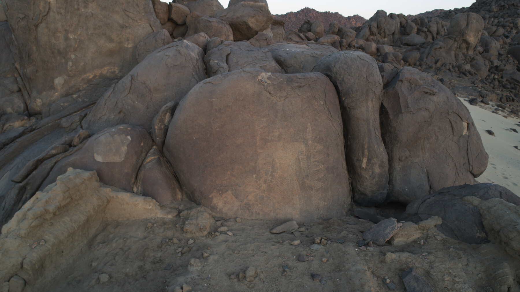
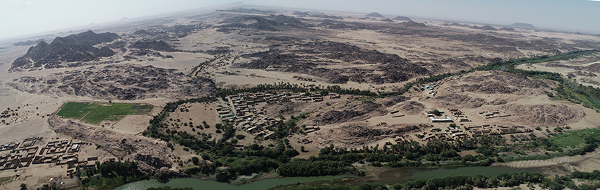
Person conducting excavation: dr. hab. Dobrochna Zielińska Country: Sudan Site name: Miseeda, region Mahas, 19°53’1.31″N 30°23’35.49″E Type of the site: church built around a rock drawing and the surrounding sites Dating: ca. 6000 BC – 19/20th cent. www: The site of Miseeda
The “Good Shepherd” of Maseeda. An image in the context of the changing cultural landscape of the Third Cataract of the Nile. – financed by NCN (UMO-2019/35/B/HS3/02440).
Near the modern village of Miseeda in the Sudanese part of Nubia, in the area of the Third Cataract, an isolated church has been preserved, which conceals a rock drawing from the Kushite period (7th century BC – 4th century AD), made at least three hundred years before the region was converted to Christianity. A certain similarity of this image to the depiction of the “Good Shepherd” known in early Christian art became the initiating factor for the entire project.
The combination of old rock drawings with much younger sacral architecture is an intriguing situation, unique in Nubia. Both the petroglyph and the church are on the spatial border, but they eliminate the border in time, connecting pre-Christian times with the Christian era.
To understand the reasons and circumstances in which this church was founded, the broader context needs to be studied and understood. Firstly, the spatial context: there are numerous rock carvings in the Third Cataract region. The second context is the period in which the drawing was made, viewed, respected, and perhaps revered. Its meaning must have been transformed between the late Meroitic period and the moment when it became an object of interest for the Christian inhabitants of this region and travelers.
Miseeda – church and surroundings, Mahas region, Sudan
Person conducting excavation: dr. hab. Dobrochna Zielińska Country: Sudan Site name: Miseeda, region Mahas, 19°53’1.31″N 30°23’35.49″E Type of the site: church built around a rock drawing and the surrounding sites
Dating: ca. 6000 BC – 19/20th cent.
http://miseeda.uw.edu.pl
The “Good Shepherd” of Maseeda. An image in the context of the changing cultural landscape of the Third Cataract of the Nile. – financed by NCN (UMO-2019/35/B/HS3/02440).
Near the modern village of Miseeda in the Sudanese part of Nubia, in the area of the Third Cataract, an isolated church has been preserved, which conceals a rock drawing from the Kushite period (7th century BC – 4th century AD), made at least three hundred years before the region was converted to Christianity. A certain similarity of this image to the depiction of the “Good Shepherd” known in early Christian art became the initiating factor for the entire project.
The combination of old rock drawings with much younger sacral architecture is an intriguing situation, unique in Nubia. Both the petroglyph and the church are on the spatial border, but they eliminate the border in time, connecting pre-Christian times with the Christian era.
To understand the reasons and circumstances in which this church was founded, the broader context needs to be studied and understood. Firstly, the spatial context: there are numerous rock carvings in the Third Cataract region. The second context is the period in which the drawing was made, viewed, respected, and perhaps revered. Its meaning must have been transformed between the late Meroitic period and the moment when it became an object of interest for the Christian inhabitants of this region and travelers.
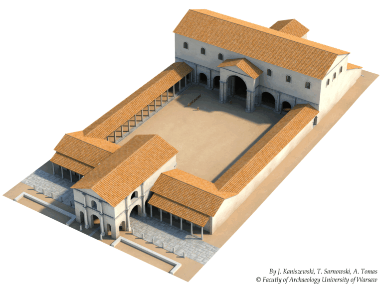
Principal investigators: prof. dr hab. Tadeusz Sarnowski†, dr hab. Agnieszka Tomas
Name of the site: Novae
Country: Bulgaria
Partner institutions: Faculty of Archaeology University of Warsaw and the National Institute of Archaeology Bulgarian Academy of Sciences with the Museum
Type of the site: Roman legionary camp (castra legionis), civil settlement (canabae legionis) and late Roman town.
Chronology: 1st-6th century AD
Numerous statue bases of deities and emperors, sacrificial altars, and building inscriptions dating from the 2nd to thirties of the 5th century AD were found in the principia of the First Italic Legion and about fifty more found elsewhere were identified as originating from this building. The main objective of this project was to complete documentation of newly discovered inscriptions, to improve the documentation of older finds according to current standards and to prepare their publication. It has to provide maximum information about the palaeography of inscriptions and dedication formulae, time, place, circumstances, reasons of setting up statues of gods and emperors, and sometimes even financing the monument, altars, building or its dependencies, most probable material used to create statues, their size, types of sculptural representation and in some cases even the statue’s physical appearance, names, origin, social status and rank of the dedicators, place and role of the represented deity in the camp religion and in religious cults practiced in the province of Lower Moesia and in the whole lower Danubian region.
Thanks to the support of the National Science Centre, a set of monuments from the principia can be documented and developed – both the bases of statues, altars and fragments of statues, as well as building inscriptions and architectural elements, which will allow not only to recreate the appearance of the building, but also its interior design and changes that this interior design underwent in time. Based on these finds, archaeologists have created a 3D visualization of the complex, which will take into account the discovered monuments and remains, and is therefore the most faithful recreation of reality over 1,700 years ago. Such a procedure allows us to better understand the reasons for and the manner in which the military erected statues and inscriptions for religious, propaganda and political purposes.
Project title/financial support: “In medio castrorum. Sculptural and epigraphic landscape of the central part of the legionary fortress at Novae”, NCN, OPUS 11, nr UMO-2016/21/B/HS3/00030, planned period of realization 02.02.2017 – 01.02.2021.
Publications:
Tadeusz Sarnowski, Novae und die legio I Italica unter Trajan und Hadrian, Archeologia 67, 2018, 57-71
Tadeusz Sarnowski, Statio publici portorii in Novae (Niedermoesien) und eine neue Statuenbasis aus dem Stabsgebäude der 1. Italischen Legion, Studia Europaea Gnesnensia 16, 2017, 77-86 (DOI 10.14746/seg.2017.16.5)
Tadeusz Sarnowski, Building the Early Christian Episcopal Complex with Inscribed Stones from the Roman Legionary Headquarters, Sacrum et profanum, Novae. Studies and Materials, vol. VI, Poznań 2018, 77-86
Tadeusz Sarnowski, Komendantura rzymskiego legionu w Novae. Od odsłoniętych ruin do pełnowymiarowej wizualizacji w terenie, in: Donum Cordis. Księga poświęcona pamięci Jerzego Kolendo, J. Jakubiak (ed.), Warszawa, 2019, 335–345 (org/10.31338/uw.9788323538554.pp.335-345)
Tadeusz Sarnowski, In medio castrorum legionis I Italicae at Novae. Preserved Remains, 3D Virtual Modelling and Full-size Visualisation on the Original Site, in: Limes XXIII. Roman Frontier Studies, Mainz 2018, 350-359
Tadeusz Sarnowski, udział w Międzynarodowej Konferencji Naukowej XIII. Limes Congress 2015 – Germany, 12th-23rd September 2015. Tytuł wystąpienia: Das Stabsgebäude des Legionslagers Novae. Baubestand virtuelle Idealrekonstruktion und Nachbau in Originallage.
Tadeusz Sarnowski, udział w Międzynarodowej Konferencji Naukowej „Roman Empire: A 21st Century Perspective… In Memoriam Geza Alföldy (1935-2011), 8-10.11.2016, Gniezno. Tytuł wystąpienia: Neues aus Novae in Niedermoesien zum illyrischen Zollbezirk.
Adam Łajtar, udział Międzynarodowej Konferencji Naukowej „3rd Conference on the Roman Danubian Provinces. Society and Economy, 10-15th November 2017, Wien”. Tytuł wystąpienia: New Inscriptions from Novae Referring to the Institution of pastus militum.
Adam Łajtar, Tomasz Płóciennik, Agnieszka Tomas, ‘A third-century senator twice-honoured at Novae’, Zeitschrift fur Papyrologie und Epigraphik 223, 2022, 243ff.
Other research project realised in Novae by the Faculty (former Institute) of Archaeology University of Warsaw:
Person conducting research: Dr Stephanie Aulsebrook Country: Greece Site name: Mycenae Type of site: settlement and extra-mural cemeteries Involved institutions: WAUW Research Assistants: Monika Łapińska, Paulina Jurkowska Date: July 2019–July 2023 Project financing: SONATA 14 NCN (DEC-2018/31/D/HS3/02231)
Project Summary: This project focused on Mycenae, the foremost centre on mainland Greece during the Late Bronze Age (17th–11th centuries BC) and the relationship between its inhabitants and metals. Metals have a very varied role in prehistoric societies. They can be used to make a wide range of objects, including tools, weapons, vessels, jewellery and armour. Until now, most research had just focused on the relationship between the upper classes and metal, so this project aimed to consider a broader range of people.
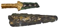
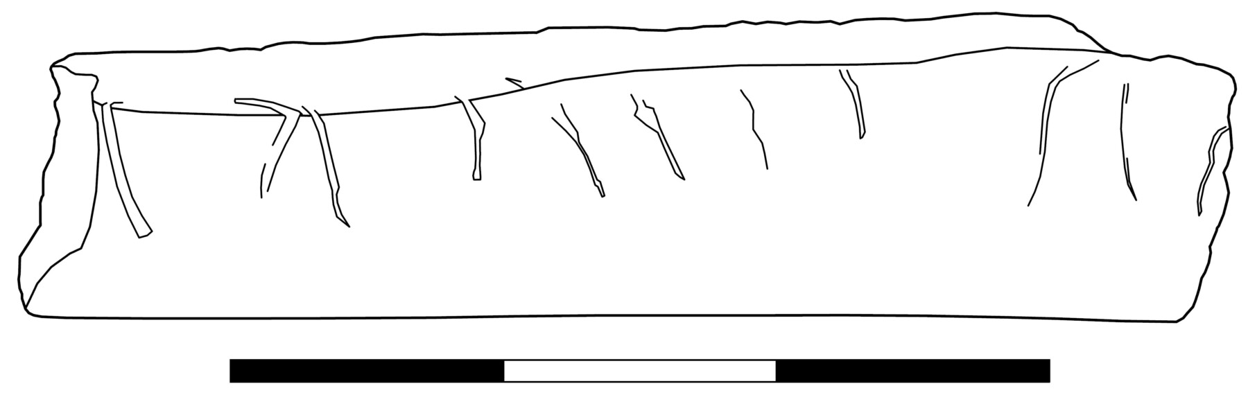
Decorated Dagger Blades from Mycenae (photo: N. Soderberg)
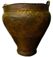
Copper Alloy Krater from Mycenae
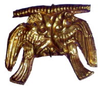
Gold Jewellery from Mycenae
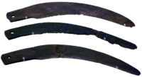
Mycenaean Sickle Blades
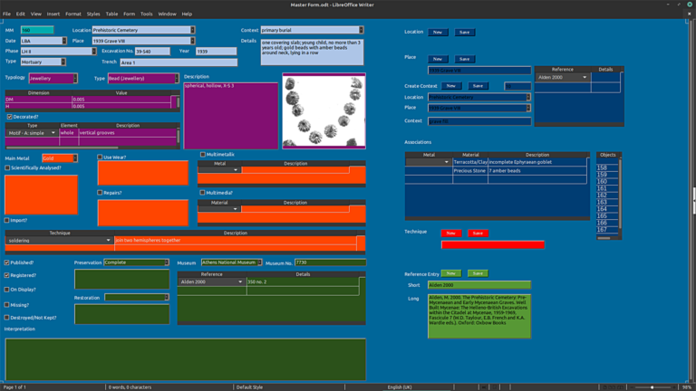
Project Methodology: the project collated together into a database all the available information on metal objects that have been excavated at Mycenae since 1876. Their distribution within the site was then analysed, along with their types and other important features.
Example of Entry in Database
The database currently contains more than 15000 metal artefacts. Of those, more than half come from documented Late Bronze Age contexts. The majority come from mortuary contexts; for example, the famous Circle A shaft graves discovered by Heinrich Schliemann in 1876 account for more than 2500 of these artefacts alone.
Project Results: the project had three main questions:
1) which activities involved metals and which did not?
Metals were found to have been used in a wide variety of activities, such as making objects, cooking, eating and drinking, personal adornment, warfare and hunting, etc. However, some types of object were never made in metal, such as certain specialised vessel shapes. Metals were apparently rarely used within textile production, in comparison to other crafts, and although gilding was a widespread form of decoration particular types of ornament were never gilded. Therefore metal was not ubiquitous, and even in the activities when it was used other materials, like ceramic or glass, were often used too.
2) how was access to metal controlled at Mycenae?
The contemporary textual records focus on the disbursement of metal by the palace, but have little evidence about access to metals for ordinary households and independent workshops. The project found that across most of Mycenae it seems that metals were melted down and recycled, showing that people were careful not to waste metal. One household, situated outside the citadel, threw away broken metal objects, suggesting they had confidence in being able to access a steady supply whenever they needed it. The complex use life of some objects (see below) indicate that the palace’s control over the metal supply was less tight than previously supposed. There is tentative evidence to indicate that some people, perhaps slaves, were not allowed to use metals for personal adornment.
3) what was the typical lifecycle for different kinds of metal artefacts and can we see deviations?
Studying metal objects under a microscope provided new insights into the lifecycles of some specimens. This chisel fragment and finger ring both had interesting stories: the chisel fragment was deliberately broken off (perhaps from a tool that was too damaged for further use) and was then used as a platform for sawing, as shown by the cut marks; the finger ring was roughly made from a spare piece of bronze wire, rather than being specially cast and shaped like most Mycenaean jewellery.
A Chisel Fragment Reused as a Cutting Platform
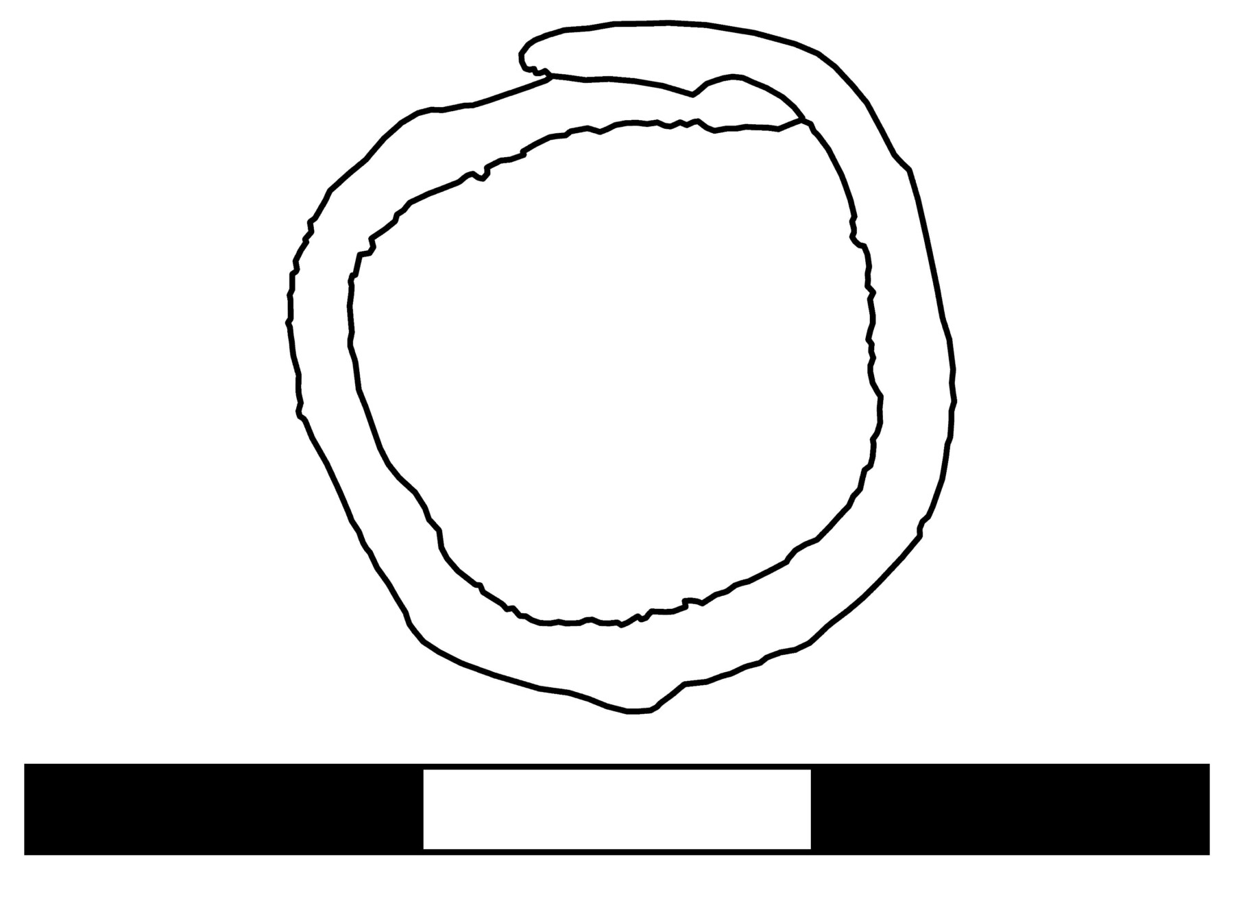
A Finger Ring Made from a Piece of Wire
The unusual stories of these two objects show that the production and use of metal artefacts at Mycenae was more complex than previously thought; control over metal was not completely in the hands of the palatial authorities. The ring in particular shows how desirable metal was, and how people sought ways to engage with it personally, even when they could not afford real jewellery.
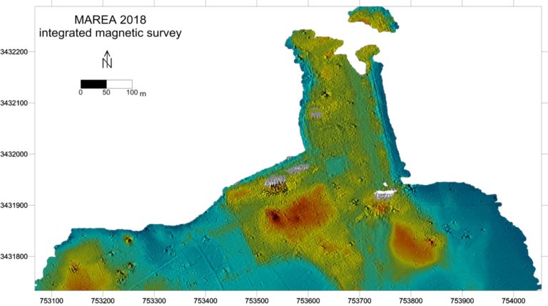
Person conducting excavation: prof. Tomasz Derda Country: Egypt Site name: Marea Type of the site: settlement and cemetery (Hellenistic, Roman, Byzantine and Early Islamic periods) Involved institutions: Faculty of Archaeology, University of Warsaw; Polish Centre of Mediterranean Archaeology University of Warsaw; Archaeological Museum in Krakow
Description of the research: On the southern shore of Lake Mariout, 45 kilometres west of Alexandria, Polish archaeologists have been excavating for several years the ruins of a large Byzantine city. The city, patiently uncovered structure after structure, was built exactly on the spot of an industrial centre and a harbour which functioned until the third century AD. Traditionally, the place was called Marea, following its (uncertain) identification with the most important urban centre in this part of the Mediterranean before the foundation of Alexandria of which we learn from Herodotus and Thucydides. A great transept basilica built in the end of the fifth century, the second largest church in Egypt (49 x 47 m), is the most magnificent building on the site. Next to the basilica, the archaeologists uncovered two bath complexes, a large house dating to the Late Antique period, warehouses, and latrines. Four massive piers (the longest measuring over 120 metres) extending deep into the lake date to the Roman period; they could serve several ships simultaneously. We know that large production workshops manufacturing pottery on a mass scale, as well as glass workshops, were located nearby. The apse of the basilica was constructed right on a pottery kiln which with its diameter of more than eight metres is one of the largest in Egypt. The kiln was used until the beginning of the third century AD, as indicated by the chronology of the last batch of amphorae prepared for firing which was found under the apse. Our neighbours on the site, archaeologists from France, have discovered on the peninsula a warehouse building functionally connected with the harbour. This structure was in use in the Ptolemaic and Early Roman periods. The remains, dated to the first century BC – beginning of the third century AD point to an intensive industrial exploitation of the area. We are in a region that produced wine on a great scale and exported it in amphorae which were also locally manufactured. The size of the kiln, the proportions of the warehouse, and the sweeping scale of the piers’ construction show that “Marea” was at the same time a remarkable industrial centre and a significant harbour.
Project of the University of Warsaw and University of Amsterdam:
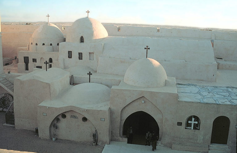
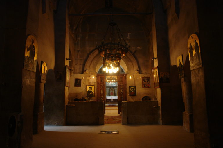
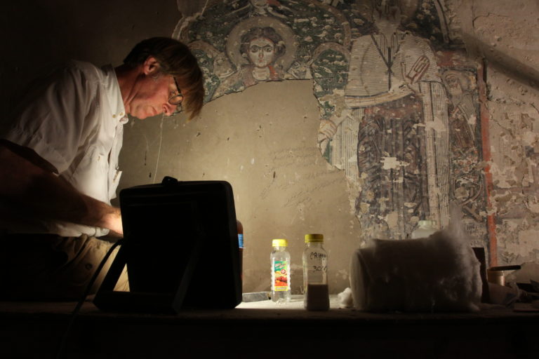
„A Cross-section in Time: The Church of the Holy Virgin in Deir al-Surian – an integrated analysis of the building, its paintings and inscriptions.”, financed by NCN (2015/18/M/HS3/00621).
Person conducting excavation: dr Karel Innemée i dr Dobrochna Zielińska Site: Monastery of the Syrians (Deir al-Surian), Wadi Natrun, Egypt Type of the site: monastic church Datowanie: 7th – 21st century
A thorough investigation of the architecture and interior decoration of the church of the Holy Virgin in Deir al-Surian (Egypt) with the aim of reconstructing the most important stages in the development of the building between its construction in the middle of the 7th century and the present. The building has undergone a number of architectural modifications and, partly in connection with this, has been re-decorated up to four times since the 7th century. Two important stages (10th and 13th centuries) can be dated to the period when the monastery was inhabited by a Syriac community. This involves important influences from Syriac culture on the monastic milieu in Egypt, an aspect that will be an important part of the research.
The layer of 18th century undecorated plaster that covers large parts of the interior are removed to uncover the stratification of mural paintings and inscriptions of various kinds that can be expected underneath. Apart from that, evidence of architectural modifications can be expected. The documentation and analysis of this material should lead to a new insight in the development of the building and its decoration, leading to conclusions concerning its use and the changes in the church. The iconography of the paintings is analysed on the basis of texts (mainly wall inscriptions accompanying the paintings, but also liturgical, patristic and other kinds of written sources) and comparison with contemporary paintings elsewhere.
The research is multidisciplinary in its approach (architecture, iconography of the paintings, epigraphy and liturgy) and for this reason specialists with a reputation in their fields have been invited to participate. This has led to establishing a cooperation between University of Amsterdam and University of Warsaw. The Dutch side in this project also collaborates with specialists from universities in the USA (Duke), Belgium (Louvain-la-Neuve) and Germany (Bonn).
Person conducting excavation: Marcin Matera, PhD Country: Russia, Tanais (Myasnikovski district, Rostov Oblast) Site name: Tanais Type of the site: Antique town Involved institutions: Museum-Reserve “Tanais”, Institute of Archaeology, University of Warsaw, Antiquity of Southeastern Europe Research Centre, University of Warsaw Description of the research:
Excavations conducted at Tanais by the University of Warsaw began in 1995 and have continued ever since . Since 1999, the Polish mission has explored Trench XXV situated at the western border of Western Tanais. Up until now, circa 1300 square metres have been investigated, which resulted in unearthing Hellenistic architectural remains: a bridge made of wood and stone leading across a defensive ditch protecting the town, a fortification complex consisting of a ditch dug from the side facing the steppe, a stone defensive wall, as well as a carefully fortified gateway to the town . Residential housing was confined inside the town walls (the rooms: ‘A’, ‘B’, ‘C’, ‘D’, ‘E’, and ‘F’) along with an urban street grid (‘a’ and ‘b’).
Currently, research is conducted within the framework of the project “Hellenistic Buildings in Tanais – fortifications and adjacent intramural district. Further research” funded by National Science Center, Poland (2016/21/B/HS3/03423).
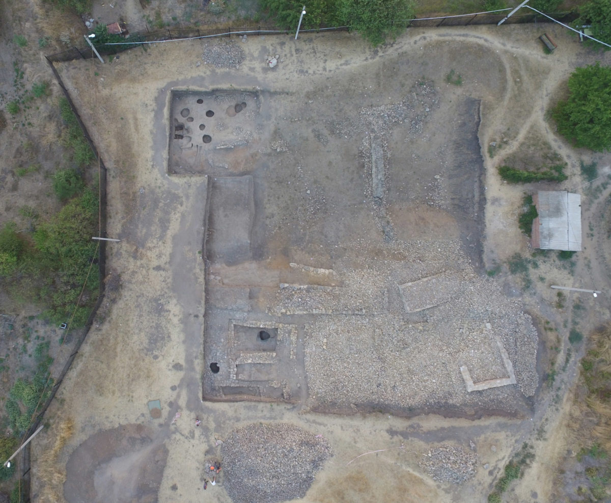
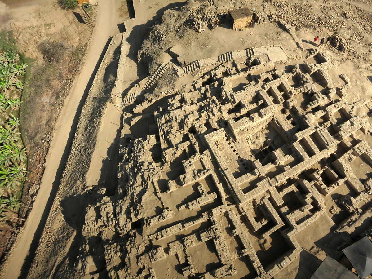
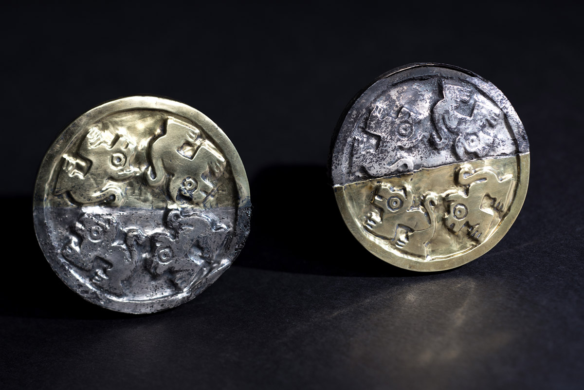
Person conducting excavation: Miłosz Giersz, PhD Country: Peru Site name: Huramey Type of the site: settlement, palace, temple, cemetery. Wari Empire (600 – 1050 n.e.). Involved institutions: IAUW, PUCP, NGS, APPEA
Description of the research:
Twelve centuries ago, in a Peruvian desert on the Pacific coast, on the outskirts of the first empire of pre-Columbian Andes, called Wari by archaeologists, a new centre of power was established, with Castillo de Huarmey as its capital. Centuries before the Inca rose to power, the rulers of the Wari Empire developed a unique culture that created rare works of art and architecture. Castillo de Huarmey became one of the richest necropolis of the Wari Empire elites.
phot. Miłosz Giersz
The Huarmey Valley, located in the Ancash region about 300 km north of the capital of Peru, Lima, is one of the many river valleys on the desert Pacific coast. In that peaceful oasis, over a millennium ago, the Wari people established a new centre of power. Castillo de Huarmey, located 1 km (0.6 mi) east from the present-day capital of the Huarmey province, covers an area of 45 ha. It is dominated by a monumental palace and the royal necropolis built above it, on the summit of a natural rock hill. Plundered and damaged over decades, only in 2010 were the ruins of the capital of a Wari Empire province finally, and extensively, studied, when a team led by Miłosz Giersz and Patrycja Prządka-Giersz, both from the University of Warsaw, with Krzysztof Makowski and Roberto Pimentel Nita from the Pontifical Catholic University of Peru (Lima), carried out the first archaeological excavations. There, after years of work, a Polish-Peruvian team of archaeologists directed by dr. Milosz Giersz from the University of Warsaw, Poland, unearthed the first undisturbed royal tomb of pre-Columbian Wari civilization that consisted of remains of 58 noblewomen, 6 human sacrifices, two mutilated guardians and over 1300 artefacts made of gold, silver, bronze, decorated pottery as well as rare wood, bone, and shell and stone materials. This discovery was considered by National Geographic Society and ARCHAEOLOGY. A publication of the Archaeological Institute of America as one of the most important archaeological findings worldwide. Those archaeological excavations brought as many unique data as new research questions that archaeologists are trying to answer by continuing multidisciplinary research at this unique pre-Columbian site.
Project financing:
The 2010 field season of the Castillo de Huarmey Archaeological Project was supported by grants from the National Science Center of the Republic of Poland (2970/B/H03/2009/37) and the Ministry of Science and Higher Education of the Republic of Poland (579/N-PERU/2009/0). The 2012-2018 field seasons of the Castillo de Huarmey Archaeological Project were supported by grants from the National Science Center of the Republic of Poland (NCN 2011/03/D/HS3/01609 and NCN 2014/14/M/HS3/00865), the National Geographic Society (EC0637-13, GEFNE85-13, GEFNE116-14 and W335-14) and financial support from Compañia Minera Antamina S.A. Many Project’s initiatives were also supported by the Foundation for Polish Science (grant KWERENDA 2011/195), the National Science Center (grants NCN 2015/18 / E / HS3 / 00106 and NCN 2015/19 / N / HS3 / 00880) and the Ministry of Science and Higher Education (Diamond Grant 2013012043), as well as the Pontifical Catholic University of Peru in Lima, Polish-Peruvian Society for Andean Studies, the Ministry of Culture of the Republic of Peru and the local government of Huarmey.
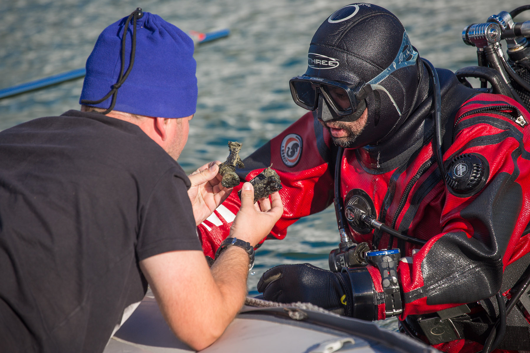
Person conducting excavation: prof. Bartosz Kontny Country: Poland Site name: Lubanowo Lake Type of the site: ritual place Involved institutions: Faculty of Archaeology, University of Warsaw; Institute of Archaeology and Ethnology, Polish Academy of Sciences
Lubanowo Lake, phot. Aleksander Kozłowski
Description of the research:
Since 2014 the team from the University of Warsaw has been conducting an underwater survey in Lake Lubanowo in Western Pomerania. It unveiled traces of a three-millennium-long human activity, including i.a. an Iron Age logboat, a Roman Period war-booty offering, Medieval deposits, a copper cauldron from ca AD 1600, private stamp of a Prussian general from the early nineteenth century. During underwater research weapons, tools, and horse harness elements were found dated mainly to the Roman Period; some of them bear traces of ritual destruction. The parallels to weapons may be pointed out namely in Central Europe and, to some extent, in Scandinavia. The site should be attributed to sacrificial military deposits, known generally from northern Europe, but until recently unknown to the south of the Baltic Sea. Its extraordinary character is manifested by the fact that the site is still in its ‘lake stage’, not a bog, into which ancient lakes have evolved due to the process of eutrophication. Most probably the site was used by local inhabitants, i.e. the people of the Lubusz group, in the 1st until the early 3rd c. AD but at least some of deposited weapons may be linked to the neighbouring cultural groups. The author presents first conclusions concerning the character of the deposit.
Literature: B. Kontny, T. Nowakiewicz, A. Rzeszotarska-Nowakiewicz, The Turning Point: preliminary results of underwater research of the former Herrn-See at the vilage of Lubanowo (Western Pomerania, Poland), “Archaeologia Baltica” 23 (2016), 45–57.
Starożytne miejsce ofiarne w jeziorze w Lubanowie na Pomorzu Zachodnim, ed. Tomasz Nowakiewicz, Warszawa: IA UW 2016.


 The research is multidisciplinary in its approach (architecture, iconography of the paintings, epigraphy and liturgy) and for this reason specialists with a reputation in their fields have been invited to participate. This has led to establishing a cooperation between University of Amsterdam and University of Warsaw. The Dutch side in this project also collaborates with specialists from universities in the USA (Duke), Belgium (Louvain-la-Neuve) and Germany (Bonn).