![]() The Greek colony Orgame and later Roman city of Argamum played a pivotal role in the seaborne commerce of north-east Moesia Inferior and later Scythia Minor. Within the ArchLiMar project, in Argamum the so-called Northern Sector is under investigation, where in Justinian times the city’s logistics centre was located, with warehouses stretching along the defensive walls, as evidenced by the architecture as well as finds of dolia, amphorae and fishing weights.
The Greek colony Orgame and later Roman city of Argamum played a pivotal role in the seaborne commerce of north-east Moesia Inferior and later Scythia Minor. Within the ArchLiMar project, in Argamum the so-called Northern Sector is under investigation, where in Justinian times the city’s logistics centre was located, with warehouses stretching along the defensive walls, as evidenced by the architecture as well as finds of dolia, amphorae and fishing weights.
AiQala
Principal Investigator: Dr. Nazarij Buławka (WAUW)
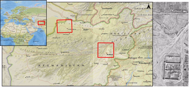
Research location: the Kabul area and the Balkh oasis in Afghanistan
Research type: research utilizing artificial intelligence and remote sensing
Chronology: all chronological phases
The AiQala project focuses on investigating the development of fortified villages, known as qala, in Afghanistan and neighboring regions.
A qala is a fortified, stand-alone village or the residence of a landowner, commonly found in Iran, Afghanistan, and neighboring countries. Settlements of this type played a key role in spatial and social organization during the Sasanian Empire (224–651 CE) and in the Islamic period. A typical qala has a rectangular layout. It is surrounded by a thick wall and protected by towers, making it easily recognizable in satellite and aerial photographs. Data on the locations of qala-type villages come from numerous ethnographic and archaeological studies. Despite extensive research, no attempts have yet been made to use artificial intelligence (deep learning) to investigate their distribution.
AiQala is a research project funded by the National Research Centers in Poland (UMO-2025/57/B/HS3/04379), aimed at elucidating the role of the qala in the development of complex societies in Afghanistan. The project involves developing deep learning models to detect fortified qala villages, the surrounding farmland patterns, and traces of water systems, including qanats (Buławka, Orengo, and Berganzo-Besga 2024).
Links
Funding
AIQala: The studies of Cultural, Socio-economic and Geographical Factors in the emergence of Fortified Settlements and its relation to irrigation systems Using Historical, Archaeological, Ethnographical Methods and Artificial Intelligence (NCN, OPUS 29, UMO-2025/57/B/HS3/04379)
Ancient Skopelos Survey

Heads of Research: Dr. Anthi Batziou (Ephorate of Magnesia, Greek Ministry of Culture), Dr. hab. Agata Ulanowska, prof. ucz. (WAUW), Dr. Filip Franković (Heidelberg University), Prof. dr hab. Peter Pavúk (Charles University in Prague)
Research Location: Skopelos, Northern Sporades, Greece
Type of Research: Surface survey of the entire island
Dating: All chronological phases, with a special focus on the Bronze Age
Webpage: https://askos.archeologia.uw.edu.pl/
Ancient Skopelos Survey (acronym ASkoS)
The Ancient Skopelos Survey (ASkoS, 2024–2028) project is a joint venture (Greek: synergasia) conducted by the Faculty of Archaeology of the University of Warsaw in cooperation with the Ephorate of Magnesia of the Greek Ministry of Culture, under the auspices and with the research permit of the Polish Archaeological Institute at Athens (PAIA), and in collaboration with the Universities of Heidelberg and Charles University in Prague.
The project aims to deepen our knowledge of the communities that inhabited the Northern Sporades in the 3rd and 2nd millennia B.C. The research focuses on Skopelos—one of the largest, yet still underexplored, islands of the Sporades. Our goal is to identify the role of Skopelos in the context of social, political, and cultural changes occurring during both millennia, including:
- Identifying and understanding the settlement network on the island, with a special focus on the processes occurring in the 3rd and 2nd millennia B.C.
- Connecting these processes with changing environmental conditions.
- Connecting these processes with the cultural, socio-political, and economic trends dominant in the Aegean at that time.
- Explaining the role of Skopelos in intra- and inter-regional interaction networks in the 3rd and 2nd millennia B.C.
- Selecting an optimal site for future excavation research.

San Isidro, El Salvador
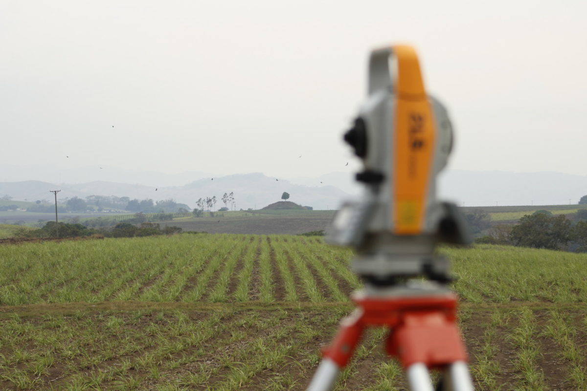
San Isidro, El Salvador
project director: Dr. Jan Szymański
research location: San Isidro archaeological site, department of Sonsonate, El Salvador, Central America
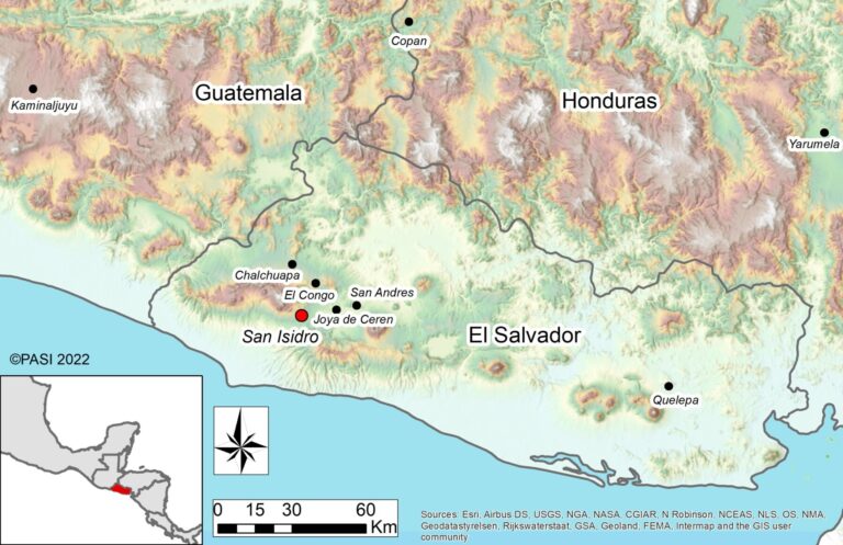
San Isidro is located in the middle of a natural corridor connecting the Pacific coast with the fertile valleys further inland.
site characteristics: The site has been continuously eroded by heavy agricultural machinery. Currently ca. 50 visible remains of monumental architecture are dispersed over the area of 6.5 km2 on a sugarcane plantation. Dating of surface collections of pottery encompasses the Middle (ca. 1000-400 BC) and the first half of the Late (ca. 400 – 1 BC) Preclassic periods. San Isidro most likely served as a large regional center at the southeastern boundary of Mesoamerica, and western fringe of Central America.
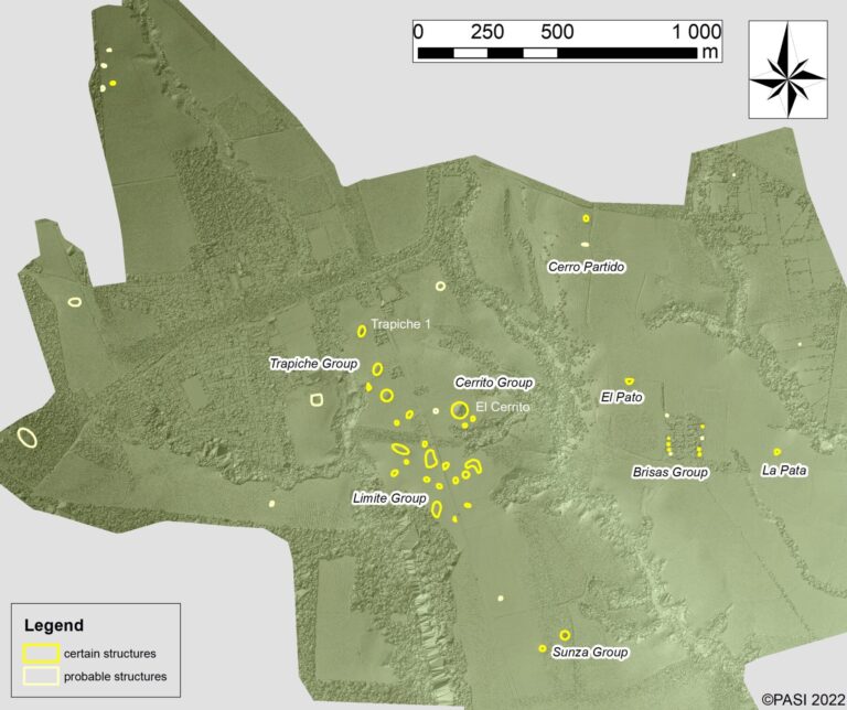
Until 2022, over 50 structures were recorded through drone surveys. Ground-truthing has been underway.
participating institutions: University of Warsaw (Poland), Dirección de Arqueología del Ministerio de Cultura (El Salvador)
dating: tentative, ~1000 – 1 BC
financing:
2024-2027 – “Opus” grant ( no. 2023/49/B/HS3/02232) titled “Rozpoznanie, analiza i interpretacja wspólnot praktyk w przedhiszpańskim zachodnim Salwadorze” (“Recognition, analysis, and interpretation of Communities of Practice in pre-Hispanic Western El Salvador”)
2021-2024 – “Sonata” grant (no. 2019/35/D/HS3/00219) titled “Na kresach Mezoameryki: badania archeologiczne stanowiska San Isidro w Salwadorze” (“On the Fringes of Mesoamerica: archaeological research at the site of San Isidro, El Salvador”)
2019 – funds from the “Excellence Strategies – Research Academy” program
2018 – “Miniatura” grant provided by the National Center for Sciences (Narodowe Centrum Nauki – NCN), (ID 381403),
research description: So far, seven research campaigns have been carried out, including two seasons of survey (2018 and 2019), one of geophysical prospection (February 2021), three of excavations (March-May 2021, 2022, 2024), and one of laboratory analyses (2023).
In 2018 a field survey was carried out, as well as partial photogrammetric documentation of the visible architectural remains. A drone-based topographic map, albeit interim, has been elaborated. The works continued through 2019. In 2021, a three-season-long excavations begun, focusing on three prominent areas of the site: the Cerrito and Trapiche groups, and El Pato structure.
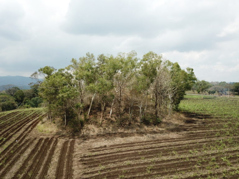
Cerrito 1 before excavations.
In the course of excavations it became apparent that the largest structures at San Isidro are made mostly of clay heaped while wet. Inside the largest building at the site – Cerrito 1 – vestiges of an earlier pyramidal structure were found, perhaps one crowned with an intentionally-destroyed shrine. Basing on radiocarbon analyses, the process of expansion of Cerrito 1 has been dated to ca. 400 BC, while the ceramic data indicates that the original structure was erected no earlier than 650 BC.
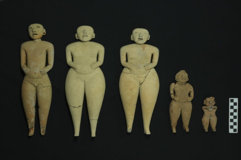
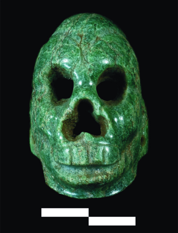
Uncomplicated constructive methods contrast with particularly large size of the site, and with rich offerings purposefully deposited within the fill of Cerrito 1. Among these, a few stacks of vessels were found, along with jade jewelry in the form of tubular and globular beads and a miniature pendant representing an abstract avian personage with folded arms. Beside it, a group of large ceramic figurines with movable heads were found, of which one represents a male with tattooed face, accompanied by two smaller figurines probably symbolizing children. Such figurines, known as Bolinas type. are exceptionally rare. The nature and position of those findings suggest that during the expansion of Cerrito 1 a rich burial was placed in the fill, albeit the body did not survive due to an elevated acidity of the soil and other unfavorable taphonomic conditions.
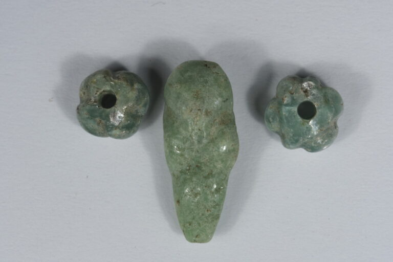
Interestingly, the figurines and the avian pendant have close analogies at a contemporaneous site of Tak’alik Ab’aj, located some 400 km west of San Isidro, on the southern Pacific slopes of Guatemalan Highlands. A well-preserved burial was found there of a ruler with a jade necklace. The necklace’s central element was a relatively large pendant in the form of a human with an avian head and arms folded across the chest. By the head of the ruler, six large Bolinas figurines were placed, of which one had a movable head.
Further analogies indicate that both pendants, that is, the San Isidro and Tak’alik Ab’aj ones, although made of Guatemalan jade, represent a figure typical for Costa Rican iconography, thus coming from ca. 1000 km away in the opposite direction, east of San Isidro. All of this points to an existence of a very early exchange route, along which travelled not only objects, but also ideas. That route cuts across cultural spheres known as Mesoamerica in the west and Isthmo-Colombian Area in the east.
A number of objects found just under the surface on the top of Cerrito 1, including remains of a calcite or travertine vessel, and a miniature jade mask representing a monkey skull, most likely come from much later times (so-called Postclassic Period, AD 900-1520) Central Mexico. Perhaps ethnolinguistic groups that migrated along the Pacific before the Conquest, made offerings on the imposing ruins of a long-abandoned city.
The research at San Isidro is ongoing. This site will be (irregularly) updated.
bibliography:
2025; Szymański J.; G. Prejs, Of puppets and puppeteers. Preclassic clay figurines from San Isidro, El Salvador, Antiquity 99(405).
2024; Szymański J.; M. Méndez, San Isidro, Sonsonate, El Salvador: Development of a Preclassic Settlement in Chronological and Geographic Context, Journal of Field Archaeology 49(5): 370-389.
2022; Szymański J.; K. Misiewicz; R. Mieszkowski; J. Martecki, Regional Patterns, Local Techniques: Remote Sensing and Archaeology at prehispanic site of San Isidro, El Salvador, Journal of Archaeological Science: Reports 45.
2020; Szymański J.; Recent Research at San Isidro, El Salvador, in the Context of the Southeastern Mesoamerican Archaeology, Estudios Latinoamericanos 40:1-28.
2018; Szymański J., M. Mendez, M. Toledo, J. Avalos Campos, R. Cabrera, R. Cea; San Isidro: Large Preclassic site at the eastern edge of the Maya Culture, Mexicon 40(40): 100-104.
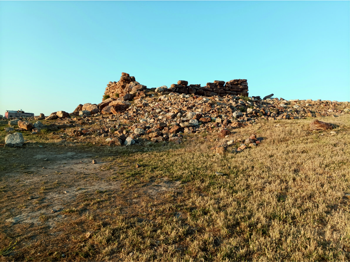
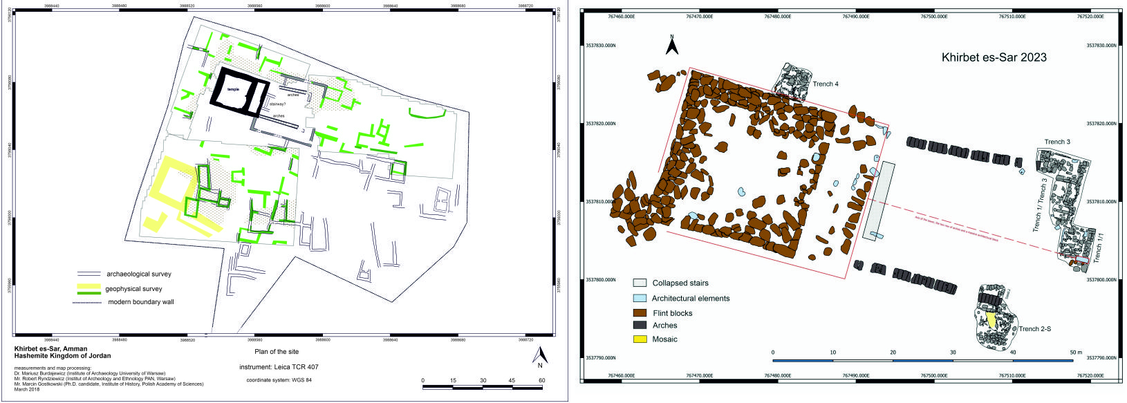
Khirbat Sarah (Khirbat as-Sar) – settlement from the Iron Age, Hellenistic, Roman, Byzantine, and Islamic periods
Person conducting excavation: Dr hab. Mariusz Burdajewicz and Prof. Jolanta Młynarczyk
Site name: Khirbat Sarah (west Amman), MEGA Jordan # 11304 (JADIS 2215017).
Country: the Hashemite Kingdom of Jordan.
Involved institutions: Faculty of Archaeology, University of Warsaw; Faculty of Conservation and Restoration of Works of Art, Academy of Fine Arts, Warsaw; Wrocław University of Science and Technology; Department of Antiquities, Jordan. In 2018-2019: Polish Centre of the Mediterranean Archaeology University of Warsaw.
Type of the site: settlement from the Iron Age, Hellenistic, Roman, Byzantine, and Islamic periods.
Description of the research:
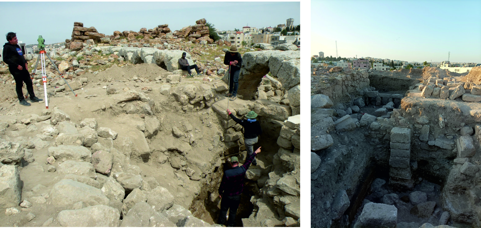
In 2018 and 2019, a team directed by Prof. Jolanta Młynarczyk from the Polish Centre of Mediterranean Archaeology University of Warsaw conducted two short seasons of work at the ancient site of Khirbat Sarah, located on the western outskirts of Amman. A geophysical and archaeological survey proved the great cognitive potential of Khirbat Sarah as an exemplary site in terms of the longue durée, occupied from the Iron (Ammonite) age till the middle Islamic period at least.
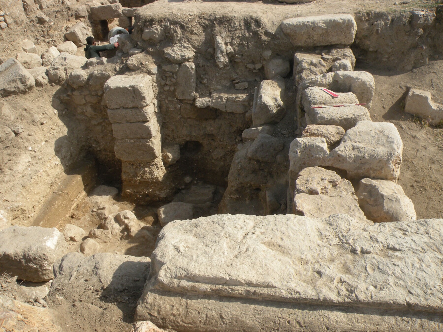
After the break caused by the COVID-19 pandemic, excavations were resumed in 2023, this time on behalf of the Faculty of Archaeology, University of Warsaw. The current project aims to define the chronology and nature of the settlement in the different phases of its history, as well as to better understand its relationship with nearby Amman during the period of over two millennia. This spectacular site, occupying an excellent strategic position on the western edge of the Amman plateau, is crowned by a monumental architectural complex. It consists of an ‘Ammonite tower,’ secondarily used in the Roman period as a temple with an arcaded courtyard added to it. This complex, surrounded by buildings of later periods, still needs to be fully recognized. Finds, mainly pottery, indicate a particularly intensive settlement from the Ayyubid-Mamluk period. Likely, a rural settlement existed here, its inhabitants involved in agriculture and animal husbandry, which provided an agricultural base for the Islamic capital of Amman. On the other hand, the unique combination of an Iron Age Ammonite tower with a temple characterized by Classical architectural order is an interesting issue related to the local community’s adaptation of a Greco-Roman material culture and religion.
The site’s ancient name remains obscure. 19th-century travelers S. Merrill and C.R. Conder identified the site with biblical Azor (Iazer), still mentioned in the 4th century by Eusebius (Onomastikon). Indeed, the very geographical situation and some archaeological evidence for a Hellenistic period habitation might suggest the identity of Khirbat Sarah with the fortified settlement of Jazer, conquered by Judah Maccabee in 163 BC (I Macc. 5,8). Under the Ptolemies, in the 3rd century BC, the site must have been a part of the region administered by the mighty family of Tobiads, suggesting its possible identification with “Birta of the Ammanitis”, mentioned in a letter from the Zeno Archive, dated 259 BC.
Further reading:
Młynarczyk J. and Burdajewicz M., with appendices by R. Ryndziewicz and J. Burdajewicz: Archaeological and geophysical survey at the site of Khirbat as-Sar (Sara), Jordan, Polish Archaeology in the Mediterranean 27/1 (2018), 341-378 (with earlier bibliography relevant to Khirbat es-Sar).
Villeneuve, F., Khirbet Sara (Jordan) 1983. In: A. Łajtar and K. Jakubiak (eds.), Ex Oriente Lux. Studies in Honour of Jolanta Młynarczyk, Warsaw (2020), 309-322.
Funding statement: The project is financed by the Polish National Science Centre (UMO-2021/43/B/HS3/00813, Opus 22).
Argamum and its hinterland: northern Dobruja and the Danube Delta
Person conducting excavation: dr Martin Lemke, dr Karolina Trusz
Country: Romania
Site name: Argamum and its hinterland: northern Dobruja and the Danube Delta
Type of the site: Greek colony, Roman fortified city, various limes fortifications.
Involved institutions: Faculty of Archaeology UW, ICEM Tulcea (Rumunia)
Description of the research:
The research involves terrestrial and underwater archaeological investigations in north-eastern Dobruja (Romania), around the ancient city of Argamum. The investigations are part of project ArchLiMar (www.archeologia.uw.edu.pl/archlimar).
Currently, selected areas are being explored using archaeological prospecting methods, scanning the ground or water to understand what might be hidden beneath the surface. These methods are called non-invasive because they do not require exploration of the ground, although future excavations will be carried out based on them.
The chronological scope of the project focuses on Antiquity and Late Antiquity: the time of the Greeks and Romans. Around the Black Sea, significant settlements appeared during Greek colonisation, and many of these towns were located in the area that later became the coast of the Roman province of Moesia inferior – modern day Romania and Bulgaria.
The central site is the Greek and Roman city of Argamum, studied on land and from the perspective of the nearby Lake Razim, using underwater methods. Such underwater prospection is also planned further south from Argamum.
More exploration, but in the Dobruja interior, will be carried out at two sites that could have been Roman forts, in order to verify this theory. Both are located in the valley of the strategically important Taița River, a natural land route crossing the Dobruja, connecting the Black Sea with the Danube.

Dealul Consul. © Fundacja Archeologii Podwodnej

Argamum. © Fundacja Archeologii Podwodnej

default
Hammersø – lake
Person conducting excavation: prof. Bartosz Kontny
Country: Danmark
Site name: Hammersø Lake, Bornholm
Type of the site:
Involved institutions: Faculty of Archaeology, University of Warsaw; Bornholms Museum
Dating: late Middle Ages-modernity
Description of the research: Since 2019 an archaeological team from the Faculty of Archaeology, University of Warsaw has been conducting underwater survey in a postglacial Lake Hammersø, in collaboration with the Bornholm Museum in Rønne. The only tarn in the territory of Denmark is located in the Hammeren region, i.e. the northernmost part of Bornholm (55°16′58″N, 14°45′54″E). It is the largest lake on the island, measuring ca. 650×150 metres with the maximum depth of ca. 13 metres. The project revealed certain phenomena from the lake’s past. A few phases of occupation may be singled out, offering a longue durée sequence of habitation in the area, from the Middle Ages until now. The most fascinating are late medieval/early modern episodes. The martial one is documented by the discoveries of several crossbow bolts and an arrowhead. With another, possibly of a ritual character, one may associate a find of a lugged spearhead and possibly also an axe. There are non-military late Medieval finds as well: ring-shaped brooch and a seal stamp. All of them give a promising perspective for combining with the history of the Hammershus castle – the largest medieval structure of that type in northern Europe – situated ca 1.5 kilometres as the crow flies. The relics of contemporary human water-related activities were also discovered in the basin: three wrecks of tourist plank-boats from the turn of the 20th century, which might be associated with the hotel’s presence, and a number of metal objects; their presence resulted from the stone industry, active until AD 1970. One may add to the list numerous fishing hooks and lures (not collected), proving the twentieth-century fishing – apparently not very intensive.

fot. Bartosz Kontny

fot. Bartosz Kontny
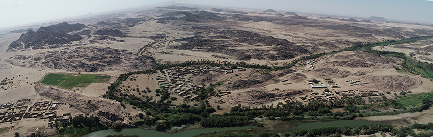
Miseeda – church and surroundings, Mahas region, Sudan
Person conducting excavation: dr. hab. Dobrochna Zielińska
Country: Sudan
Site name: Miseeda, region Mahas, 19°53’1.31″N 30°23’35.49″E
Type of the site: church built around a rock drawing and the surrounding sites
Dating: ca. 6000 BC – 19/20th cent.
www: The site of Miseeda
The “Good Shepherd” of Maseeda. An image in the context of the changing cultural landscape of the Third Cataract of the Nile. – financed by NCN (UMO-2019/35/B/HS3/02440).
Near the modern village of Miseeda in the Sudanese part of Nubia, in the area of the Third Cataract, an isolated church has been preserved, which conceals a rock drawing from the Kushite period (7th century BC – 4th century AD), made at least three hundred years before the region was converted to Christianity. A certain similarity of this image to the depiction of the “Good Shepherd” known in early Christian art became the initiating factor for the entire project.
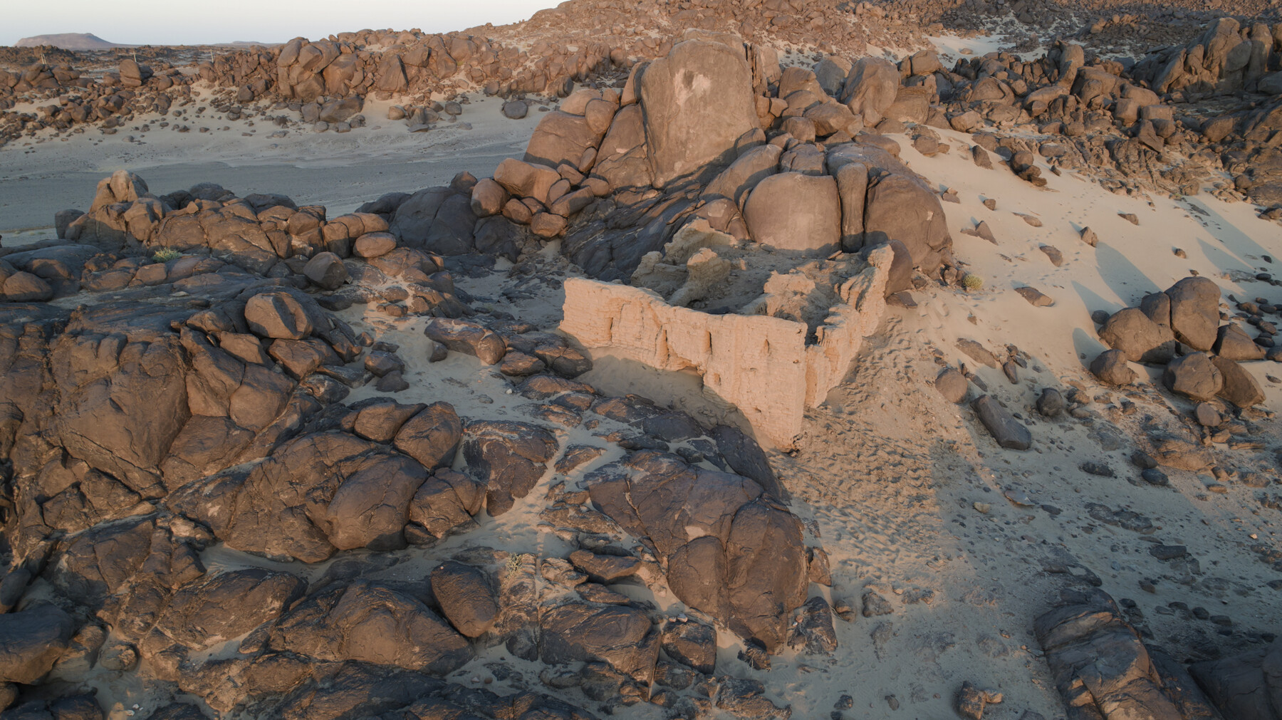
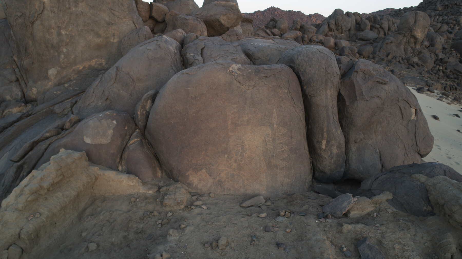
The combination of old rock drawings with much younger sacral architecture is an intriguing situation, unique in Nubia. Both the petroglyph and the church are on the spatial border, but they eliminate the border in time, connecting pre-Christian times with the Christian era.
To understand the reasons and circumstances in which this church was founded, the broader context needs to be studied and understood. Firstly, the spatial context: there are numerous rock carvings in the Third Cataract region. The second context is the period in which the drawing was made, viewed, respected, and perhaps revered. Its meaning must have been transformed between the late Meroitic period and the moment when it became an object of interest for the Christian inhabitants of this region and travelers.
Miseeda – church and surroundings, Mahas region, Sudan
Miseeda – church and surroundings, Mahas region, Sudan
Person conducting excavation: dr. hab. Dobrochna Zielińska
Country: Sudan
Site name: Miseeda, region Mahas, 19°53’1.31″N 30°23’35.49″E
Type of the site: church built around a rock drawing and the surrounding sites
Dating: ca. 6000 BC – 19/20th cent.
http://miseeda.uw.edu.pl
The “Good Shepherd” of Maseeda. An image in the context of the changing cultural landscape of the Third Cataract of the Nile. – financed by NCN (UMO-2019/35/B/HS3/02440).
Near the modern village of Miseeda in the Sudanese part of Nubia, in the area of the Third Cataract, an isolated church has been preserved, which conceals a rock drawing from the Kushite period (7th century BC – 4th century AD), made at least three hundred years before the region was converted to Christianity. A certain similarity of this image to the depiction of the “Good Shepherd” known in early Christian art became the initiating factor for the entire project.
The combination of old rock drawings with much younger sacral architecture is an intriguing situation, unique in Nubia. Both the petroglyph and the church are on the spatial border, but they eliminate the border in time, connecting pre-Christian times with the Christian era.
To understand the reasons and circumstances in which this church was founded, the broader context needs to be studied and understood. Firstly, the spatial context: there are numerous rock carvings in the Third Cataract region. The second context is the period in which the drawing was made, viewed, respected, and perhaps revered. Its meaning must have been transformed between the late Meroitic period and the moment when it became an object of interest for the Christian inhabitants of this region and travelers.
Novae – sculptural and epigraphic landscape of the central part of the legionary fortress
Principal investigators: prof. dr hab. Tadeusz Sarnowski†, dr hab. Agnieszka Tomas
Name of the site: Novae
Country: Bulgaria
Partner institutions: Faculty of Archaeology University of Warsaw and the National Institute of Archaeology Bulgarian Academy of Sciences with the Museum
Type of the site: Roman legionary camp (castra legionis), civil settlement (canabae legionis) and late Roman town.
Chronology: 1st-6th century AD
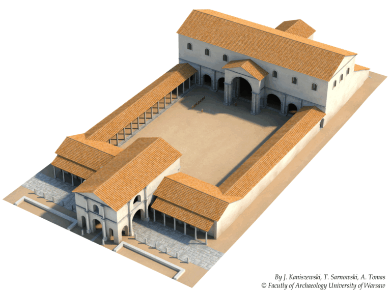
Numerous statue bases of deities and emperors, sacrificial altars, and building inscriptions dating from the 2nd to thirties of the 5th century AD were found in the principia of the First Italic Legion and about fifty more found elsewhere were identified as originating from this building. The main objective of this project was to complete documentation of newly discovered inscriptions, to improve the documentation of older finds according to current standards and to prepare their publication. It has to provide maximum information about the palaeography of inscriptions and dedication formulae, time, place, circumstances, reasons of setting up statues of gods and emperors, and sometimes even financing the monument, altars, building or its dependencies, most probable material used to create statues, their size, types of sculptural representation and in some cases even the statue’s physical appearance, names, origin, social status and rank of the dedicators, place and role of the represented deity in the camp religion and in religious cults practiced in the province of Lower Moesia and in the whole lower Danubian region.
Thanks to the support of the National Science Centre, a set of monuments from the principia can be documented and developed – both the bases of statues, altars and fragments of statues, as well as building inscriptions and architectural elements, which will allow not only to recreate the appearance of the building, but also its interior design and changes that this interior design underwent in time. Based on these finds, archaeologists have created a 3D visualization of the complex, which will take into account the discovered monuments and remains, and is therefore the most faithful recreation of reality over 1,700 years ago. Such a procedure allows us to better understand the reasons for and the manner in which the military erected statues and inscriptions for religious, propaganda and political purposes.
Project title/financial support: “In medio castrorum. Sculptural and epigraphic landscape of the central part of the legionary fortress at Novae”, NCN, OPUS 11, nr UMO-2016/21/B/HS3/00030, planned period of realization 02.02.2017 – 01.02.2021.
![]()
Publications:
- Tadeusz Sarnowski, Novae und die legio I Italica unter Trajan und Hadrian, Archeologia 67, 2018, 57-71
- Tadeusz Sarnowski, Statio publici portorii in Novae (Niedermoesien) und eine neue Statuenbasis aus dem Stabsgebäude der 1. Italischen Legion, Studia Europaea Gnesnensia 16, 2017, 77-86 (DOI 10.14746/seg.2017.16.5)
- Tadeusz Sarnowski, Building the Early Christian Episcopal Complex with Inscribed Stones from the Roman Legionary Headquarters, Sacrum et profanum, Novae. Studies and Materials, vol. VI, Poznań 2018, 77-86
- Tadeusz Sarnowski, Komendantura rzymskiego legionu w Novae. Od odsłoniętych ruin do pełnowymiarowej wizualizacji w terenie, in: Donum Cordis. Księga poświęcona pamięci Jerzego Kolendo, J. Jakubiak (ed.), Warszawa, 2019, 335–345 (org/10.31338/uw.9788323538554.pp.335-345)
- Tadeusz Sarnowski, In medio castrorum legionis I Italicae at Novae. Preserved Remains, 3D Virtual Modelling and Full-size Visualisation on the Original Site, in: Limes XXIII. Roman Frontier Studies, Mainz 2018, 350-359
- Tadeusz Sarnowski, udział w Międzynarodowej Konferencji Naukowej XIII. Limes Congress 2015 – Germany, 12th-23rd September 2015. Tytuł wystąpienia: Das Stabsgebäude des Legionslagers Novae. Baubestand virtuelle Idealrekonstruktion und Nachbau in Originallage.
- Tadeusz Sarnowski, udział w Międzynarodowej Konferencji Naukowej „Roman Empire: A 21st Century Perspective… In Memoriam Geza Alföldy (1935-2011), 8-10.11.2016, Gniezno. Tytuł wystąpienia: Neues aus Novae in Niedermoesien zum illyrischen Zollbezirk.
- Adam Łajtar, udział Międzynarodowej Konferencji Naukowej „3rd Conference on the Roman Danubian Provinces. Society and Economy, 10-15th November 2017, Wien”. Tytuł wystąpienia: New Inscriptions from Novae Referring to the Institution of pastus militum.
- Adam Łajtar, Tomasz Płóciennik, Agnieszka Tomas, ‘A third-century senator twice-honoured at Novae’, Zeitschrift fur Papyrologie und Epigraphik 223, 2022, 243ff.
Other research project realised in Novae by the Faculty (former Institute) of Archaeology University of Warsaw:
Novae 2012-2015. Research on settlement structures near the Roman legionary camp at Novae (Lower Moesia) using non-destructive prospection methods (A. Tomas, completed)
Novae 2009-2011. The headquarters building and the fortifications (T. Sarnowski, completed)